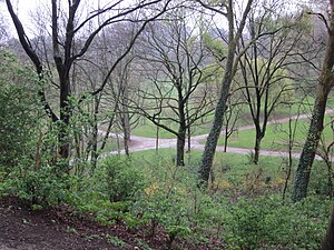
Forest Park, Brussels
| Forest Park | |
|---|---|
 Forest Park in the winter | |
 | |
| Type | Public park |
| Location | Forest, Brussels-Capital Region, Belgium |
| Coordinates | 50°49′21″N 4°20′13″E / 50.82250°N 4.33694°E |
| Area | 13 hectares (32 acres) |
| Created | 1882 |
Forest Park (French: Parc de Forest) or Vorst Park (Dutch: Park van Vorst) is a public park located in and named after the municipality of Forest in Brussels, Belgium. It was designed by Victor Besme and occupies an area of 13 hectares (32 acres).[1]
Forest Park is adjacent to Duden Park to its south, which is home to the football ground of Royale Union Saint-Gilloise, the historical football club from the neighbouring municipality of Saint-Gilles, although the club is not located in the municipality, whose border with Forest is to the north of Forest Park.
The park is surrounded by a set of streets that connect the Avenue Albert/Albertlaan to the Avenue Wielemans Ceuppens/Wielemans Ceuppenslaan, making them part of the Greater Ring. Those streets are the Avenue des Villas/Villalaan to the north, the Avenue du Mont Kemmel/Kemmelberglaan to the east, the Avenue Besme/Besmelaan to the south and the Avenue Reine Marie-Henriette/Koningin Maria-Hendrikalaan to the south-west.
-
View of the park from its hill
See also
[edit]References
[edit]Citations
[edit]- ^ "Parcs et Jardins de la Région Bruxelles Capitale". Archived from the original on 16 December 2004. Retrieved 23 April 2010.
- ^ Borowski, Zbigniew; Zub, Karol; Jacob, Jens (April 2019). "Applied research for optimized vertebrate management: 11 th European Vertebrate Pest Management Conference". Pest Management Science. 75 (4): 885–886. doi:10.1002/ps.5302. PMID 30848566.
Bibliography
[edit]- Demey, Thierry (2010). Bruxelles en vert. Le guide des jardins publics (in French). Brussels: Badeaux. ISBN 978-2-930609-00-3.
External links
[edit] Media related to Parc of Forest/Vorst at Wikimedia Commons


![Pine trees in the park, colonised by parakeets[2]](http://upload.wikimedia.org/wikipedia/commons/thumb/f/fd/Le_rep%C3%A8re_des_perruches_au_parc_de_Forest_%28Bruxelles%29.jpg/300px-Le_rep%C3%A8re_des_perruches_au_parc_de_Forest_%28Bruxelles%29.jpg)