
Foxup
| Foxup | |
|---|---|
.svg) Foxup Location within North Yorkshire | |
| Population | 17 |
| OS grid reference | SD868767 |
| Civil parish | |
| Unitary authority | |
| Ceremonial county | |
| Region | |
| Country | England |
| Sovereign state | United Kingdom |
| Post town | SKIPTON |
| Postcode district | BD23 |
| Dialling code | 01756 |
| Police | North Yorkshire |
| Fire | North Yorkshire |
| Ambulance | Yorkshire |
| UK Parliament | |
Foxup is a hamlet in the Yorkshire Dales in the Craven district of North Yorkshire, England. The hamlet is near Halton Gill and Litton and is 13 miles (21 km) north west of Grassington.[1] Foxup is in the civil parish of Halton Gill.[2]
The source of the River Skirfare starts here at the confluence of Foxup Beck and Cosh Beck.[3] The bridge over Foxup Beck in the hamlet is 17th century and was listed Grade II in 1958.[4]
The village marks the end of the main road through Littondale. There are a number of Public Footpaths and Bridleways in and around the village.[5] The area is a mixture of sheep and beef farming.[6] Dairy farming is harder than in comparison to other locations further down the valley because of the limitations on grass types and transportation of dairy produce out of the area.[7]
The name Foxup is of Old English origin, meaning "fox valley", from fox and hop "small enclosed valley", apparently in contrast to the adjacent valley of Cosh Beck, known as Harrop, meaning "hare valley".[8]
Images[edit]
-
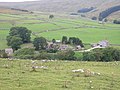 Foxup seen from Low Bergh
 -
 Foxup
Foxup -
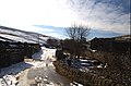
 Foxup Beck


References[edit]
- ^ "98" (Map). Wensleydale & Upper Wharfedale. 1:50,000. Landranger. Ordnance Survey. 2016. ISBN 9780319261965.
- ^ A proposal in 2011 to amalgamate the civil parishes of Halton Gill and Litton was not pursued. "The Craven District Council (Reorganisation of Community Governance) Order 2011". Craven District Council. 23 December 2011. p. 2. Archived from the original (PDF) on 3 September 2014. Retrieved 1 October 2016.
- ^ Bagshaw, Mike (2014). "17: Littondale". Yorkshire Dales (Slow Travel). Chalfont St Peter: Bradt. p. 82. ISBN 978-1-84162-549-2.
- ^ Historic England. "Foxup Bridge in front of Foxup Bridge Farm (1132181)". National Heritage List for England. Retrieved 1 October 2016.
- ^ "Walk 1278 - Cosh & Foxup from Halton Gill". Walking Britain. Retrieved 1 October 2016.
- ^ Tunningley, Claire (20 March 2014). "Upper Wharfe Sub-Catchment Evidence Pack for the Water Framework Directive" (PDF). Yorkshire Dales Rivers Trust. YDRT. Retrieved 1 October 2016.
- ^ Benn, Victoria (15 March 2014). "Littondale farmer follows the family tradition". Craven Herald & Pioneer. Retrieved 1 October 2016.
- ^ Smith, A. H. (1961). The Place-names of the West Riding of Yorkshire. Vol. 6. Cambridge University Press. p. 122.
External links[edit]
![]() Media related to Foxup at Wikimedia Commons
Media related to Foxup at Wikimedia Commons
- Foxup and Cosh on Littondale website