
Fra Mauro map


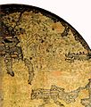
The Fra Mauro map, "considered the greatest memorial of medieval cartography" according to Roberto Almagià,[1] is a map made around 1450 by the Venetian monk Fra Mauro. It is a circular planisphere drawn on parchment and set in a wooden frame, about two meters in diameter.
A copy of the world map was made by Fra Mauro and his assistant Andrea Bianco, a sailor-cartographer, under a commission by king Afonso V of Portugal. This copy was completed on April 24, 1459, and sent to Portugal, but did not survive to the present day.
The map was discovered in the monastery of San Michel in Isola, Murano, where the Camaldolese cartographer had his studio, and is now located in a stairway in the Biblioteca Nazionale Marciana in Venice, but is visible by entering in the Museo Correr, where it is accessible from the easternmost room upon request to the museum attendants there.
A number of historians of cartography, staring with Giacinto Placido Zurla (1806) studied Fra Mauro's map.[2] A critical edition of the map was edited by Piero Falchetta in 2006.
World map
The Fra Mauro map is unusual, but typical of Fra Mauro's portolan charts, in that its orientation is with the south at the top, one of the usual conventions of Muslim maps, in contrast with the Ptolemy map which has the north at the top. Fra Mauro was aware of the Ptolemy map, and commented that it was insufficient for many parts of the world:
"I do not think it derogatory to Ptolemy if I do not follow his Cosmografia, because, to have observed his meridians or parallels or degrees, it would be necessary in respect to the setting out of the known parts of this circumference, to leave out many provinces not mentioned by Ptolemy. But principally in latitude, that is from south to north, he has much 'terra incognita', because in his time it was unknown". (Text from Fra Mauro map)
He recognized however the extent of the East given by Ptolemy, thereby suppressing the central position that Jerusalem had held on previous maps:
"Jerusalem is indeed the center of the inhabited world latitudinally, though longitudinally it is somewhat to the west, but since the western portion is more thickly populated by reason of Europe, therefore Jerusalem is also the center longitudinally if we regard not empty space but the density of population". (Text from Fra Mauro map)
As was generally the case among Medieval scholars, Fra Mauro regarded the world as a sphere. However, he used the convention of describing the continents surrounded by water within the shape of a disc, but had no certainty about the size of the Earth:
"Likewise I have found various opinions regarding this circumference, but it is not possible to verify them. It is said to be 22,500 or 24,000 miglia or more, or less according to various considerations and opinions, but they are not of much authenticity, since they have not been tested". (Text from Fra Mauro map)
Although miglia is the Italian translation for miles, the modern mile was not standardized to be exactly 5,280 feet until 1592, so the intended estimation is somewhat ambiguous. Notably, the guess here only slightly underestimates the mean circumference of the Earth (approximately 24,880 miles). The depiction of inhabited places and mountains, the map's chorography is also an important feature. Castles and cities are identified by pictorial glyphs representing turreted castles or walled towns, distinguished in order of their importance.
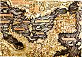
Africa


The description of Africa is reasonably accurate.[5] Fra Mauro puts the following inscription by the southern tip of Africa, which he names the "Cape of Diab", describing the exploration by a ship from the East around 1420:[3][4]
"Around 1420 a ship, or junk, from India crossed the Sea of India towards the Island of Men and the Island of Women, off Cape Diab, between the Green Islands and the shadows. It sailed for 40 days in a south-westerly direction without ever finding anything other than wind and water. According to these people themselves, the ship went some 2,000 miles ahead until - once favourable conditions came to an end - it turned round and sailed back to Cape Diab in 70 days".
"The ships called junks (lit. "Zonchi") that navigate these seas carry four masts or more, some of which can be raised or lowered, and have 40 to 60 cabins for the merchants and only one tiller. They can navigate without a compass, because they have an astrologer, who stands on the side and, with an astrolabe in hand, gives orders to the navigator". (Text from the Fra Mauro map, 09-P25.)
Fra Mauro explained that he obtained the information from "a trustworthy source", who traveled with the expedition, possibly the Venetian explorer Niccolò da Conti who happened to be in Calicut, India at the time the expedition left:
"What is more, I have spoken with a person worthy of trust, who says that he sailed in an Indian ship caught in the fury of a tempest for 40 days out in the Sea of India, beyond the Cape of Soffala and the Green Islands towards west-southwest; and according to the astrologers who act as their guides, they had advanced almost 2,000 miles. Thus one can believe and confirm what is said by both these and those, and that they had therefore sailed 4,000 miles".
Some of the islands named in the area of the southern tip of Africa bear Arabian and Indian names: Negila ("celebration" in Arabic), or Mangula ("fortunate" in Sanskrit.).
Fra Mauro also comments that the account of this expedition, together with the relation by Strabo of the travels of Eudoxus of Cyzicus from Arabia to Gibraltar through the southern Ocean in Antiquity, led him to believe that the Indian Ocean was not a closed sea and that Africa could be circumnavigated by her southern end (Text from Fra Mauro map, 11,G2). This knowledge, together with the map depiction of the African continent, probably encouraged the Portuguese to intensify their effort to round the tip of Africa.
Japan
The Fra Mauro map is one of the first Western maps to represent the islands of Japan (possibly after the De Virga world map). A part of Japan, probably Kyūshū, appears below the island of Java, with the legend "Isola de Cimpagu" (a mis-spelling of Cipangu).
Origins


As Piero Falchetta notes, there are many geographical facts reflected in Fra Mauro map for which it is not clear what Fra Mauro's source was, as no similar information is found in other preserved Western maps or manuscripts of the period.[6] This situation can be at least partially explained by the fact that, besides the existing maps and manuscripts, an important source of information for his map were oral accounts from travelers - Venetians or foreigners - coming to Venice from all parts of the then-known world. The importance of such accounts is indicated by Fra Mauro himself in a number of inscriptions.[7] An even earlier map, the De Virga world map (1411-1415) also depicts the old world in a way broadly similar to the Fra Mauro map, and may have contributed to it.
The book of travels of Marco Polo is believed to be one of the most important sources of information, in particular about the East Asia.[8] Fra Mauro also probably relied on Arab sources. This is suggested by the North-South inversion of the map, an Arab tradition exemplified by the 12th century maps of Muhammad al-Idrisi, and the detailed information on the southeastern coast of Africa, which was brought by an Ethiopian embassy to Rome in the 1430s.
Gallery
-
 Fra Mauro's Africa (south is at the top, with the "Cape of Diab" marking the southern point)
 -
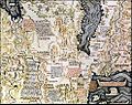
 Part of China
 -
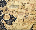
 Spain, Portugal and Northern Africa
 -
 Europe
 -
 The Middle-East
 -
 Depiction of a Chinese junk, an Atlantic ship and a Mediterranean ship in the Fra Mauro map.
 -
 Ships of the world in 1460, according to the Fra Mauro map. Chinese junks are described as very large, three or four-masted ships
 -
 The first mention of Java in a Western map
 -
 High Resolution Full View.


.jpg)
See also
Notes
- ^ Almagià, discussing the copy of another map by Fra Mauro, in the Vatican Library: Roberto Almagià, Monumenta cartographica vaticana, (Rome 1944) I:32-40.
- ^ Zurla 1806
- ^ a b The book of Ser Marco Polo, the Venetian p.409
- ^ a b Science and civilisation in China Joseph Needham p.501
- ^ Woodward, David Art and Cartography University of Chicago Press 1987 ISBN:978-0226907222 p113 [1]
- ^ Falchetta 2006, pp. 24, 35
- ^ Falchetta 2006, p. 33
- ^ Falchetta 2006, p. 34
References
- Falchetta, Piero (2006), Fra Mauro's World Map, Brepols, ISBN 2503517269
- Zurla, Placido (1806), Il mappamondo di fra Mauro, Venice
{{citation}}: Cite has empty unknown parameter:|1=(help)
External links
- Fra Mauro, c.1450 1804 copy in the British Library. Deep zoom feature, highlighted details. Video introduction from Curator of Antiquarian Mapping
- Monograph on Fra Mauro's map
- Compilation of the text on Fra Mauro's map (Italian).