Full Sutton Airfield
Full Sutton Airfield | |||||||||||
|---|---|---|---|---|---|---|---|---|---|---|---|
| Summary | |||||||||||
| Airport type | Public | ||||||||||
| Operator | Full Sutton Flying Centre Ltd | ||||||||||
| Serves | York | ||||||||||
| Location | Full Sutton | ||||||||||
| Elevation AMSL | 86 ft / 26 m | ||||||||||
| Coordinates | 53°58′50″N 000°51′53″W / 53.98056°N 0.86472°W | ||||||||||
| Website | www.fullsuttonairfield.com | ||||||||||
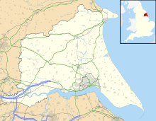
| Map | |||||||||||
 | |||||||||||
| Runways | |||||||||||
| |||||||||||
Sources: Full Sutton Airfield[1] | |||||||||||
Full Sutton Airfield (ICAO: EGNU) is an unlicensed aerodrome located 8 nautical miles (15 km; 9.2 mi) east of York in the East Riding of Yorkshire, England. It is located adjacent to, and south-east of, Full Sutton Prison.[2]
The Airfield previously held a CAA Ordinary Licence that allowed flights for the public transport of passengers, or for flying instruction as authorised by the licensee, Full Sutton Flying Centre Limited. This licence was given up in 2011.[3] The airfield is not licensed for night use.[4]
Facilities and services
Full Sutton provides instruction for PPL and CPL students.[5] The airfield employs five flying instructors, two full-time, and three part-time.[5] Facilities include a club house for the airfield flying club, hangars, control room, and on-site aircraft maintenance. It provides hire for aircraft types:
- Cessna 150
- Cessna 152
- 2 x Piper PA 28 Cherokee 140
- 2 x Piper PA 28 Warrior 160
- Slingsby T67 Firefly
- Cessna F182 Skylane
- Cessna 310
- Cessna 421 Golden Eagle[6]
Runway
Runway 04/22 at Full Sutton is a grass surface, 772 by 19 m (2,533 by 62 ft) strip and is the only runway in use at the aerodrome.[7]
References
- ^ Full Sutton Airfield
- ^ "Google Maps". Retrieved 30 November 2010.
- ^ "Full Sutton Airfield Information". Retrieved 29 January 2011.
- ^ Civil Aviation Authority Aerodrome Ordinary Licences Archived 28 June 2007 at the Wayback Machine
- ^ a b "Full Sutton Airfield, Home". Retrieved 30 November 2010.
- ^ "Full Sutton Fleet List". Retrieved 30 November 2010.
- ^ "Airfield chart". Retrieved 30 November 2010.

