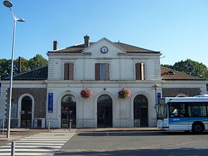
Trappes station
Appearance
This article relies largely or entirely on a single source. (October 2016) |
 | ||||||||||||||||
| General information | ||||||||||||||||
| Location | ||||||||||||||||
| Coordinates | 48°46′30″N 2°00′24″E / 48.77500°N 2.00667°E | |||||||||||||||
| Operated by | Transilien | |||||||||||||||
| Line(s) | ||||||||||||||||
| History | ||||||||||||||||
| Opened | 12 July 1849 | |||||||||||||||
| Services | ||||||||||||||||
| ||||||||||||||||
Trappes is a station situated on the Paris–Brest railway. It is served by suburban Transilien Line N and U services. The station opened on 12 July 1849.[1] It is within Trappes.
See also
Wikimedia Commons has media related to Gare de Trappes.
References
- ^ Lavigne, Raymond (1997). Trappes, Mémoires d'avenir (in French). p. 61. ISBN 2951013108.
