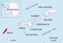
Garmen Point


Garmen Point ([нос Гърмен] Error: {{Lang-xx}}: text has italic markup (help), ‘Nos Garmen’ \'nos 'g&r-men\) is a point on the northwest coast of Smith Island, South Shetland Islands situated 13.65 km north-northeast of Cape James, 6.12 km south-southwest of Markeli Point and 19.65 km southwest of Cape Smith. Formed by an offshoot of Mount Foster. Bulgarian early mapping in 2008. Named after the settlement of Garmen in southwestern Bulgaria.
62°59′12″S 62°35′56″W / 62.98667°S 62.59889°W
Maps
- L.L. Ivanov. Antarctica: Livingston Island and Greenwich, Robert, Snow and Smith Islands. Scale 1:120000 topographic map. Troyan: Manfred Wörner Foundation, 2009. ISBN 978-954-92032-6-4
References
This article includes information from the Antarctic Place-names Commission of Bulgaria which is used with permission.
