Goidschalxoord
Goidschalxoord | |
|---|---|
Hamlet | |
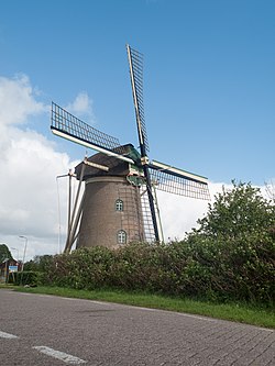
 The windmill of Goidschalxoord | |
| Coordinates: 51°49′37″N 4°27′34″E / 51.82694°N 4.45944°E | |
| Country | Netherlands |
| Province | South Holland |
| Municipality | Hoeksche Waard |
Goidschalxoord (Dutch pronunciation: [ˈɣoːtsxɑl(ə)ksoːrt]) is a hamlet in the Dutch province of South Holland. It is located about 5 km east of Oud-Beijerland, in the municipality of Hoeksche Waard.[1]
History
[edit]A ferry from Goidschalxoord to Rhoon existed before 1537. In 1888, a bridge was built, and in 1941, the ferry was taken out of service. The bridge was demolished after the Heinenoordtunnel on the A29 opened.[2] The current name was first attested in 1841, and refers to Goidschalck Oelm who was the ambachtsheer (predecessor of mayor).[3]
The nameless grist mill of Goidschalxoord was built in 1718. In 1931, a diesel motor was installed. The windmill was in service until c. 1953. In 2007, the ownership was transferred to a foundation who won the BankGiro Loterij Restauratie, and received €1 million. In 2011, the windmill returned to active service.[4]
Goidschalxoord was a separate municipality between 1817 and 1855, when it merged with Heinenoord.[5]
Goidschalxoord is not a statistical entity,[6] and considered part of Heinenoord. It has place name signs, and consists of about 100 houses.[2]
References
[edit]- ^ Wet samenvoeging gemeenten Binnenmaas, Cromstrijen, Korendijk, Oud-Beijerland en Strijen, 11 July 2018, accessed at overheid.nl
- ^ a b "Goidschalxoord". Plaatsengids (in Dutch). Retrieved 3 May 2022.
- ^ "Goidschalxoord - (geografische naam)". Etymologiebank (in Dutch). Retrieved 3 May 2022.
- ^ "(grondzeiler)". Molen database (in Dutch). Retrieved 3 May 2022.
- ^ Ad van der Meer and Onno Boonstra, "Repertorium van Nederlandse gemeenten", KNAW, 2006. "KNAW > Publicaties > Detailpagina". Archived from the original on 2007-02-20. Retrieved 2009-12-03.
- ^ "Kerncijfers wijken en buurten 2021". Central Bureau of Statistics. Retrieved 3 May 2022.
not found


