
Grand Turk Island
| Lua error in Module:Location_map at line 525: Unable to find the specified location map definition: "Module:Location map/data/Turks caicos islands sm04.png" does not exist. | |
| Geography | |
|---|---|
| Location | Caribbean |
| Coordinates | 21°28′20″N 71°08′20″W / 21.47222°N 71.13889°W |
| Archipelago | Turks Islands |
| Area | 18 km2 (6.9 sq mi) |
| Administration | |
| Demographics | |
| Population | 3,720 |
| Pop. density | 206.67/km2 (535.27/sq mi) |
Grand Turk Island is an island in the Turks and Caicos Islands. It is the largest island in the Turks Islands (the smaller of the two archipelagos that make up the island nation) with 18 km2 (6.9 sq mi). Grand Turk contains the territory's capital, Cockburn Town and the JAGS McCartney International Airport. The island is the administrative, historic, cultural and financial center of the territory, and has the second largest population of the islands at approximately 3,720 people.
Grand Turk was first colonised in 1681 by Bermudians, who set up the salt industry in the islands.[1] In 1766 it became the capital of the country. For some time, at least until the early 19th century, Grand Turk was often referred to as Grand Cay,[2] not to be confused with either Grand Cay in the Bahamas or Grand Cayman.
The name comes from a species of cactus on the island, the Turk's Cap Cactus (Melocactus intortus), which has a distinctive cap, reminiscent of an Ottoman fez.
Grand Turk gained international attention in 1962 when John Glenn's Friendship 7 Mercury spacecraft landed in the vicinity of Grand Turk Island off the southeast shoreline. A replica of the Friendship 7 is on display in Grand Turk at the entrance to the Grand Turk Island airport.[3]
In 1966 at least five Arcas (All-Purpose Rocket for Collecting Atmospheric Soundings) sounding rockets were launched from Grand Turk Island by the USA.[4]
Columbus landfall theory
Grand Turk has been put forward as the possible landfall island of Christopher Columbus during his first voyage to the New World in 1492.[5][6] San Salvador Island or Samana Cay in the Bahamas is traditionally identified with Guanahani, the site of Columbus' first landfall, but some believe that studies of Columbus' journals show that his descriptions of Guanahani much more closely fit Grand Turk than they do other candidates.[7] Magnetic variations that caused misreadings in Columbus' compasses demonstrate that several of the recorded moorings using a rope-secured anchor to a clear sandy bottom would not have been possible had Columbus sailed from the islands of the Bahamas.[8] In addition, the latitudes recorded in Columbus' diary place the landfall island at 90 nautical miles from Hispaniola, too close for the Bahamas, but almost exactly the distance from Grand Turk.[8]
On the contrary, historian Gregory McIntosh has concluded that Grand Turk was not Guanahani but Babueca, an island separately discovered by Martín Alonso Pinzón in November - December 1492.[9]
-
 Replica of the Friendship 7
 -
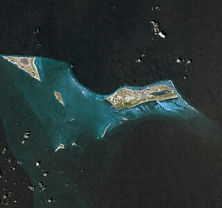 Grand Turk Island as seen from space in 2009


References
- ^ About Grand Turk - Visit Turks and Caicos Islands
- ^ Rellie, Annalisa; Hayne, Tricia (2008). Turks and Caicos. Bradt Travel Guides. p. 155. ISBN 978-1-84162-268-2.
- ^ "History of the Turks and Caicos Islands". Visit Turks & Caicos Islands. Retrieved 20 February 2015.
- ^ Frasketi, Jr., Joseph J. "The Grand Turk Island Connection with". Joe Frasketi's Space and other Topical Covers. Retrieved 20 February 2015.
{{cite web}}: CS1 maint: multiple names: authors list (link) - ^ Dyson, John. Columbus: For Gold, God, and Glory, (Toronto, Ontario, Canada: Madison Press Books, 1991), p. 164-165. ISBN 0-340-48794-1
- ^ Power, Robert H. (1983). "The Discovery of Columbus's Island Passage to Cuba, October 12–27, 1492". Terrae Incognitae. 15: 151–172.
- ^ "Columbus Monuments Pages - Columbus' First Landfall".
- ^ a b Handy, Gemma (7 August 2016). "Following Columbus: The team trying to rewrite the explorer's route". BBC.com. BBC. Retrieved 7 August 2016.
- ^ McIntosh, Gregory (1992). "Martín Alonso Pinzón's Discovery of Babueca and the Identity of Guanahani". Terrae Incognitae (24): 79–100. Retrieved 20 August 2016.
External links
- Grand Turk - Visit Turks and Caicos Islands
- Grandturk.tc
- Grand Turk Chamber of Commerce
 Grand Turk travel guide from Wikivoyage