GRACE and GRACE-FO
Template:FixBunching Template:Infobox Spacecraft Template:FixBunching
Template:FixBunchingThe Gravity Recovery And Climate Experiment (GRACE), a joint mission of NASA and the German Space Agency, has been making detailed measurements of Earth's gravity field since its launch in March 2002.
Gravity is determined by mass. By measuring gravity, GRACE shows how mass is distributed around the planet and how it varies over time. GRACE data are important tools for studying Earth's ocean, geology, and climate.
GRACE is a collaborative endeavor involving the Center for Space Research at the University of Texas, Austin; NASA's Jet Propulsion Laboratory, Pasadena, Calif.; the German Space Agency and Germany's National Research Center for Geosciences, Potsdam.[1] The Jet Propulsion Laboratory is responsible for the overall mission management under the NASA ESSP program.
The principal investigator is Dr. Byron Tapley of the University of Texas Center for Space Research, and the co-principal investigator is Dr. Christoph Reigber of the GeoForschungsZentrum (GFZ) Potsdam.[2]
The GRACE satellites were launched from Plesetsk Cosmodrome, Russia on a Rockot (SS-19 + Breeze upper stage) launch vehicle, on March 17, 2002.
Discoveries and Applications

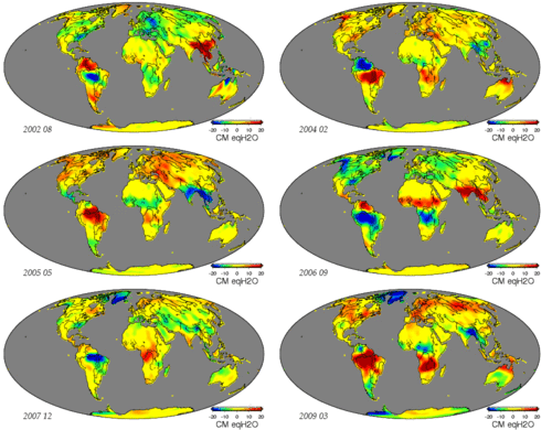
The monthly gravity maps generated by Grace are up to 1,000 times more accurate than previous maps, substantially improving the accuracy of many techniques used by oceanographers, hydrologists, glaciologists, geologists and other scientists to study phenomena that influence climate.[3]
From the thinning of ice sheets to the flow of water through aquifers and the slow currents of magma inside Earth, measurements of the amount of mass involved provided by GRACE help scientists better understand these important natural processes.

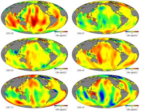
Among the first important applications for GRACE data was to improve the understanding of global ocean circulation. The hills and valleys in the ocean's surface are due to currents and variations in Earth's gravity field. GRACE enables separation of those two effects to better measure ocean currents and their effect on climate. GRACE data are also critical in helping to determine the cause of sea level rise, whether it is the result of mass being added to the ocean, from melting glaciers, for example, or from thermal expansion of warming water or changes in salinity.[4]


The data so far obtained by GRACE are the most precise gravimetric data yet recorded: they have been used to re-analyse data obtained from the LAGEOS experiment to try to measure the relativistic frame-dragging effect.
In 2006, a team of researchers led by Ralph von Frese and Laramie Potts used GRACE data to discover the 480-kilometer (300-mile) wide Wilkes Land crater in Antarctica, which probably formed about 250 million years ago.[5]
GRACE has been used to map the hydrologic cycle in the Amazon River basin and the location and magnitude of post-glacial rebound from changes in the free air gravity anomaly.
GRACE data have also been used to analyze the shifts in the Earth's crust caused by the earthquake that created the 2004 Indian Ocean tsunami.[6] Scientists have recently developed a new way to calculate ocean bottom pressure--as important to oceanographers as atmospheric pressure is to meteorologists--using GRACE data.[7]
How GRACE Works
GRACE is the first Earth-monitoring mission in the history of space flight whose key measurement is not derived from electromagnetic waves either reflected off, emitted by, or transmitted through Earth's surface and/or atmosphere. Instead, the mission uses a microwave ranging system to accurately measure changes in the speed and distance between two identical spacecraft flying in a polar orbit about 220 kilometers (137 miles) apart, 500 kilometers (311 miles) above Earth. The ranging system is so sensitive it can detect separation changes as small as 10 microns—about one-tenth the width of a human hair over a distance of 220 kilometers. [8]
As the twin GRACE satellites circle the globe 16 times a day, they sense minute variations in Earth's gravitational pull. When the first satellite passes over a region of slightly stronger gravity, a gravity anomaly, it is pulled slightly ahead of the trailing satellite. This causes the distance between the satellites to increase. The first spacecraft then passes the anomaly, and slows down again; meanwhile the following spacecraft accelerates, then decelerates over the same point.
By measuring the constantly changing distance between the two satellites and combining that data with precise positioning measurements from Global Positioning System (GPS) instruments, scientists can construct a detailed map of Earth's gravity.
The two satellites (nicknamed "Tom" and "Jerry") constantly maintain a two-way microwave-ranging link between them. Fine distance measurements are made by comparing frequency shifts of the link. As a cross-check, the vehicles measure their own movements using accelerometers. All of this information is then downloaded to ground stations. To establish baseline positions and fulfill housekeeping functions, the satellites also use star cameras, magnetometers, and GPS receivers. The GRACE vehicles also have optical corner reflectors to enable laser ranging from ground stations, bridging the range between spacecraft positions and Doppler ranges.
Spacecraft
The spacecraft were manufactured by Astrium of Germany, using its "Flexbus" platform. The microwave RF systems, and attitude determination and control system algorithms were provided by Space Systems/Loral. The star cameras used to measure the spacecraft attitude were provided by Technical University of Denmark. The instrument computer along with a highly precise BlackJack GPS receiver and digital signal processing system has been provided by JPL in Pasadena. The highly precise accelerometer that is needed to separate atmospheric and solar wind effects from the gravitation data was manufactured by ONERA.
See also
- Gravity Field and Steady-State Ocean Circulation Explorer (GOCE, launched March 2009)
References
- ^ "Grace Space Twins Set to Team Up to Track Earth's Water and Gravity". NASA/JPL.
- ^ "Mission Overview". University of Texas. 19 Nov. 2008. Retrieved 2009-07-30.
{{cite web}}: Check date values in:|date=(help) - ^ "New Gravity Mission on Track to Map Earth's Shifty Mass". NASA/JPL.
- ^ "What's Up with Sea Level". NASA/JPL.
- ^ "Big Bang in Antarctica--Killer Crater Found Under Ice". Ohio State University.
- ^ "Before the '04 Tsunami, an Earthquake So Violent It Even Shook Gravity". The New York Times.
- ^ "Gravity data sheds new light on ocean, climate". NASA/JPL.
- ^ "GRACE Launch Press Kit" (PDF). NASA/JPL.
External links
- GRACE mission home page (Primary Investigator)
- GRACE Tellus (JPL)
- GRACE mission home page (co Primary Investigator) (language: German)
- GRACE Mission Profile by NASA's Solar System Exploration
- Science@NASA article about GRACE
- Weighing Earth's Water from Space Estimating ground water using GRACE (written for non-scientists)
- Report by BBC showing early results
- GPS World Discussion of instrumentation
