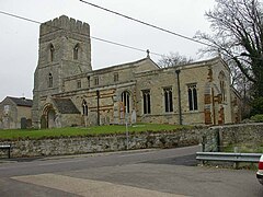
Great Addington
This article needs additional citations for verification. (November 2009) |
| Great Addington | |
|---|---|
 All Saints Church, Great Addington | |
| Population | 327 (2011 census) |
| OS grid reference | SP9574 |
| District | |
| Shire county | |
| Region | |
| Country | England |
| Sovereign state | United Kingdom |
| Post town | Kettering |
| Postcode district | NN14 |
| Dialling code | 01536 |
| Police | Northamptonshire |
| Fire | Northamptonshire |
| Ambulance | East Midlands |
| UK Parliament | |
Great Addington is a small village and civil parish in Northamptonshire, England. It lies near the west bank of the River Nene, about 5 miles (8 km) east of Kettering. It consists of approximately 100 households; at the time of the 2011 census, the population of the parish (including Slipton) was 327 people.[1] It has a school, church, manor house, village hall, a pub called the Hare & Hounds, playing fields and homes. There is a strong bond and rivalry with the neighbouring village Little Addington.
There is evidence of Celtic, Romano-British and Anglo-Saxon settlement within the village boundary.[citation needed]
Geography
Nearby settlements include Little Addington, Woodford, Ringstead, Denford, Irthlingborough, Raunds, Thrapston, Higham Ferrers, Kettering, Chelveston, Wellingborough and Stanwick.
References
- ^ Office for National Statistics: Great Addington CP: Parish headcounts. Retrieved 15 July 2015
External links
