
Gyantse


Gyantse (rGyal rtse) also spelled Gyangtse, Gyangdzê; (Standard Tibetan: རྒྱལ་རྩེ་ Chinese: 江孜镇; Wylie: rgyal rtse;) is a town located in Gyangzê County, Shigatse Prefecture. It is the fourth largest town in Tibet (after Lhasa, Shigatse and Chamdo).
Gyantse's population is about 8,000 people.[1] It is 3,977 metres (13,050 ft) above sea level, and is located 254 km southwest of Lhasa in the fertile plain of the Nyang Chu valley and on the Friendship Highway, which connects Kathmandu, Nepal to Lhasa, Tibet.
The town is strategically located in the Nyang River Valley on the ancient trade routes from the Chumbi Valley, Yatung and Sikkim, which met here. From Gyantse, routes led to Shigatse downstream and also over the Karo La (Pass) to Central Tibet.[2]
The fortress (constructed in 1390)[3] guarded the southern approaches to the Tsangpo Valley and Lhasa.[4]
Gyantse was the third largest city in Tibet before being overtaken by Chamdo. It is often referred to as the "Hero City" because during the British Younghusband expedition of 1904, the 500 soldiers of the Gyantse dzong held the fort for several days before they were overcome by the British forces.
Gyantse is notable for its magnificent tiered Kumbum (literally, '100,000 images') of the Palcho Monastery, the largest chörten in Tibet. The Kumbum was commissioned by a Gyantse prince in 1427 and was an important centre of the Sakya school of Tibetan Buddhism. This religious structure contains 77 chapels in its six floors, and is illustrated with over 10,000 murals, many showing a strong Nepali influence which have survived pretty well intact. They are the last of this type in Tibet. Many of the restored clay statues are of less artistry than the destroyed originals - but they are still spectacular.[5][6]
The town was nearly destroyed in 1954 and was largely emptied of people by the Chinese in 1959. During the Cultural Revolution the fort, the monastery and Kumbum were ransacked or destroyed.[7]
The main building of the Pelkor Chode or Palcho Monastery and the Kumbum have been largely restored but the dzong or fort is still largely in ruins but there is an "Anti-British Imperialism Museum" there which gives the Chinese version of the 1904 British invasion.[8]
The BBC Four documentary "A Year in Tibet" focused on the lives of ordinary Tibetans living in this city.[citation needed]
Footnotes
- ^ "Tibet: Transformation and tradition." BBC News 5 March, 2008.
- ^ Dowman, Keith. 1988. The Power-places of Central Tibet: The Pilgrim's Guide. Routledge & Kegan Paul, London and New York. ISBN 0-7102-1370-0, p. 269
- ^ Vitali, Roberto. Early Temples of Central Tibet, p. 133. (1990). Serindia Publications. London. ISBN 0-906026-25-3.
- ^ Allen, Charles. (2004). Duel in the Snows: The True Story of the Younghusband Mission to Lhasa, p. 30. John Murray (publishers), London. ISBN 0-7195-5427 6.
- ^ Dowman, Keith. 1988. The Power-places of Central Tibet: The Pilgrim's Guide. Routledge & Kegan Paul, London and New York. ISBN 0-7102-1370-0, p. 27o
- ^ Mayhew, Bradley and Kohn, Michael. (2005). Tibet, p. 167. Lonely Planet Publications. ISBN 1-74059-523-8.
- ^ Tibet: a travel survival kit. (1986) Michael Buckley and Robert Strauss, p. 158. Lonely Planet Publications, South Yarra, Australia. ISBN 0-0908086-88-1.
- ^ Tibet, p. 168. 6th edition. (2005). Bradley Mayhew and Michael Kohn. Lonely Planet. ISBN 1-74059-523-8.
Gallery
-
 Entrance to Pango Chorten, Gyantse, 1993
 -
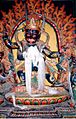
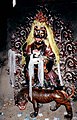 Wrathful Deity, Pango Chorten, Gyantse.
 -
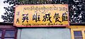 "Musilin Restaurant of the Hero City"
 -
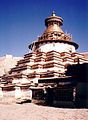 Pango Chorten, Gyantse.
 -
 A street in Gyantse old town
 -
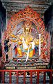
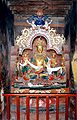 Tara statue. Gyantse Kumbum. 1993
 -
 Protective deity, Gyantse Kumbum. 1993
 -
 Sitting Buddha, Gyantse Kumbum. 1993
 -
 Deity, Gyantse Kumbum. 1993
 -
 Statue, Gyantse Kumbum. 1993
 -
 Gyantse fort from Kumbum roof. 1993
 -
Gyantse street showing Kumbum & fort. 1993
-
 Small chorten, Gyantse. 1938.
 -
 Fortress wall. Gyantse. 1938.
 -
 Building in Gyantse. 1938.


