
Happy Valley, New Mexico
Happy Valley, New Mexico | |
|---|---|
 Happy Valley | |
| Coordinates: 32°25′26″N 104°17′27″W / 32.42389°N 104.29083°W | |
| Country | United States |
| State | New Mexico |
| County | Eddy |
| Area | |
| • Total | 2.159 sq mi (5.59 km2) |
| • Land | 2.156 sq mi (5.58 km2) |
| • Water | 0.003 sq mi (0.008 km2) |
| Elevation | 3,209 ft (978 m) |
| Population | |
| • Total | 519 |
| • Density | 240/sq mi (93/km2) |
| Time zone | UTC-7 (Mountain (MST)) |
| • Summer (DST) | UTC-6 (MDT) |
| Area code | 575 |
| GNIS feature ID | 2584108[2] |
Happy Valley is an unincorporated community and census-designated place in Eddy County, New Mexico, United States. Its population was 519 as of the 2010 census.[1] The community is located on the western edge of Carlsbad; New Mexico State Road 524 passes through the area.
Geography
Happy Valley is located at 32°25′26″N 104°17′27″W / 32.423909°N 104.290790°W. According to the U.S. Census Bureau, the community has an area of 2.159 square miles (5.59 km2), of which 2.156 square miles (5.58 km2) are land and 0.003 square miles (0.0078 km2) are water.[1]
References
Municipalities and communities of Eddy County, New Mexico, United States | ||
|---|---|---|
| Cities | 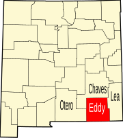 | |
| Villages | ||
| CDPs | ||
| Unincorporated communities | ||
This New Mexico state location article is a stub. You can help Wikipedia by expanding it. |