Herten, Netherlands
Appearance
Herten | |
|---|---|
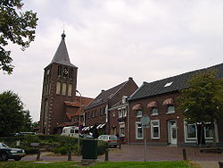
 The centre of Herten, with the church of St. Michaël | |
 | |
| Country | Netherlands |
| Province | Limburg |
| Municipality | Roermond |
Herten is a village in the southeastern Netherlands. It is located in the municipality of Roermond, Limburg.
Herten was a separate municipality until 1991, when it was merged with Roermond.[1] The municipality also covered the smaller villages of Merum and Ool.
The church of St. Michaël was built in 1954 and was designed by Hendrik Willem Valk.
References
- ^ Ad van der Meer and Onno Boonstra, "Repertorium van Nederlandse gemeenten", KNAW, 2006. "Archived copy". Archived from the original on 2007-02-20. Retrieved 2009-12-03.
{{cite web}}: Unknown parameter|deadurl=ignored (|url-status=suggested) (help)CS1 maint: archived copy as title (link)
External links
51°11′N 5°58′E / 51.183°N 5.967°E
