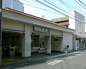
Hirama Station
This article needs additional citations for verification. (March 2015) |
Hirama Station 平間駅 | |
|---|---|
 Hirama Station entrance in November 2011 | |
| General information | |
| Location | Tajiri-chō, Nakahara, Kawasaki, Kanagawa (神奈川県川崎市中原区田尻町) Japan |
| Operated by | JR East |
| Line(s) | Nambu Line |
| Connections |
|
| History | |
| Opened | 1927 |
| Passengers | |
| FY2008 | 14,303 daily |
Hirama Station (平間駅, Hirama-eki) is a railway station on the Nambu Line in Nakahara-ku, Kawasaki, Kanagawa Prefecture, Japan, operated by East Japan Railway Company (JR East).
Lines
Hirama Station is served by the Nambu Line from Kawasaki to Tachikawa, and lies 5.3 km from the southern terminus of the Nambu Line at Kawasaki.
Station layout
Hirama Station has two opposed side platforms serving two tracks, connected by a footbridge.
Platforms
| 1 | ■ Nambu Line | for Kawasaki |
| 2 | ■ Nambu Line | for Musashi-Kosugi, Musashi-Mizonokuchi, Noborito, and Tachikawa |
Facilities
- Kiosk
- Lavatory
- Automatic ticket barriers
Adjacent stations
| « | Service | » | ||
|---|---|---|---|---|
| Nambu Line | ||||
| Rapid: Does not stop at this station | ||||
| Kashimada | Local | Mukaigawara | ||
History
Hirama Station opened as a station on the Nambu Railway on March 9, 1927. The stop was upgraded to become a full station along with nationalization of Nambu Railway on April 1, 1944, into the Japanese Government Railways (JGR) system, which became part of the Japanese National Railways (JNR) from 1949. Along with privatization and division of JNR, JR East started operating the station on April 1, 1987.
See also
References
- Harris, Ken and Clarke, Jackie. Jane's World Railways 2008-2009. Jane's Information Group (2008). ISBN 0-7106-2861-7
