
Hirschville, North Dakota
Hirschville, North Dakota | |
|---|---|
 St. Philip's Cemetery in Hirschville | |
 Hirschville Location within the state of North Dakota  Hirschville Hirschville (the United States) | |
| Coordinates: 47°04′05″N 102°33′50″W / 47.06806°N 102.56389°W | |
| Country | United States |
| State | North Dakota |
| County | Dunn |
| Time zone | UTC-6 (Central (CST)) |
| • Summer (DST) | UTC-5 (CDT) |
| Area code | 701 |
| GNIS feature ID | 1029476 |
Hirschville is an unincorporated community in Dunn County, North Dakota, United States.[1]
On December 12, 1910, Casper and Marianna Hirsch donated 6 acres (24,000 m2) of land for St. Philip's Catholic Church to hold services for German-speaking immigrants. Shortly after the church was completed, Casper Hirsch established a grocery and hardware store nearby.
On May 11, 1911, a U.S. post office was annexed to the general store. The station was called Hirschville in commemoration of its founder, Casper Hirsch (1865–1931).[2]
References
Municipalities and communities of Dunn County, North Dakota, United States | ||
|---|---|---|
| Cities | 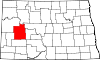 | |
| CDP | ||
| Other communities | ||
| Indian reservation | ||
| Footnotes | ‡This populated place also has portions in an adjacent county or counties | |
This North Dakota location article is a stub. You can help Wikipedia by expanding it. |