Huimbayoc District
Appearance
Huimbayoc
Wimpayuq | |
|---|---|
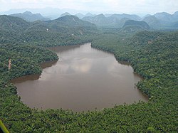
 Laguna del Mundo Perdido, Huimbayoc District, Cordillera Azul National Park | |
 | |
| Country | |
| Region | San Martín |
| Province | San Martín |
| Founded | December 30, 1953 |
| Capital | Huimbayoc |
| Government | |
| • Mayor | Lucas Reynaldo Arevalo Cumapa |
| Area | |
| • Total | 1,609.07 km2 (621.27 sq mi) |
| Elevation | 120 m (390 ft) |
| Population | |
| • Total | 4,539 |
| • Density | 2.8/km2 (7.3/sq mi) |
| Time zone | UTC-5 (PET) |
| UBIGEO | 220907 |
Huimbayoc or Wimpayuq (Quechua) is one of fourteen districts of the province San Martín in Peru.[1]
Part of the district is located in the Cordillera Azul National Park.
References
- ^ Template:Es icon Instituto Nacional de Estadística e Informática. Banco de Información Distrital Archived 2008-04-23 at the Wayback Machine. Retrieved April 11, 2008.
