
Iborfia
You can help expand this article with text translated from the corresponding article in Hungarian. (February 2016) Click [show] for important translation instructions.
|
Iborfia | |
|---|---|
| Country | |
| County | Zala |
| Area | |
| • Total | 2.59 km2 (1.00 sq mi) |
| Population (2009) | |
| • Total | 11 |
| • Density | 7.33/km2 (19.0/sq mi) |
| Time zone | UTC+1 (CET) |
| • Summer (DST) | UTC+2 (CEST) |
| Postal code | 8984 |
| Area code | 92 |
Iborfia is a village in Zala County, Hungary.
Gallery
-
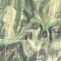
 The map of Iborfia from the First Military Mapping Survey of Austria Empire.
 -
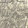
 The map of Iborfia from the Second Military Mapping Survey of Austria Empire.
 -
 The map of Iborfia from the 3rd Military Mapping Survey of Austria-Hungary.


External links
This Zala location article is a stub. You can help Wikipedia by expanding it. |

.svg)