
File:Countries with autonomous regions.png

Size of this preview: 800 × 351 pixels. Other resolutions: 320 × 140 pixels | 640 × 281 pixels | 1,425 × 625 pixels.
Original file (1,425 × 625 pixels, file size: 37 KB, MIME type: image/png)
| This is a file from the Wikimedia Commons. Information from its description page there is shown below. Commons is a freely licensed media file repository. You can help. |
Summary
| Description |
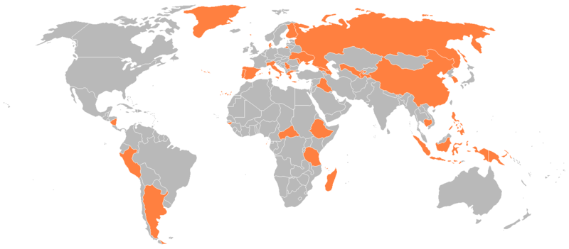
English: Countries with an autonomous region. |
| Date | |
| Source |
en:Image:Countries with autonomous regions.png Originally uploaded 21:09, 9 January 2008 (UTC) by Genjix (talk • contribs) to en:Wikipedia (log). |
| Author | en:User:Genjix |
| Permission (Reusing this file) |
{{PD-user-en}} |
Licensing
| This work has been released into the public domain by its author, Genjix at English Wikipedia. This applies worldwide. In some countries this may not be legally possible; if so: Genjix grants anyone the right to use this work for any purpose, without any conditions, unless such conditions are required by law. |
File history
Click on a date/time to view the file as it appeared at that time.
| Date/Time | Thumbnail | Dimensions | User | Comment | |
|---|---|---|---|---|---|
| current | 20:05, 30 April 2016 | | 1,425 × 625 (37 KB) | Janitoalevic | Colored Faroe Islands |
| 20:00, 30 April 2016 |  | 1,425 × 625 (37 KB) | Janitoalevic | Original size and colors | |
| 03:39, 30 April 2016 |  | 1,918 × 1,020 (146 KB) | Bettyreategui | Imagen equivocada, mi error | |
| 03:36, 30 April 2016 |  | 1,918 × 1,020 (146 KB) | Bettyreategui | El Perú tiene a su capital y la ciudad del Callao como ciudades con elevación de regiones | |
| 20:25, 5 February 2012 |  | 1,425 × 625 (54 KB) | Mapmaster | Colors were passed (Rusdsian Islands and West part of New Guinea) | |
| 20:22, 5 February 2012 |  | 1,425 × 625 (54 KB) | Mapmaster | The Russian Islands and the Indonesian Part of New Guinea were colored. | |
| 16:01, 26 August 2008 |  | 1,425 × 625 (31 KB) | RsAzevedo | {{Information |Description={{en|1=Countries with an autonomous region.}} |Source=en:Image:Countries_with_autonomous_regions.png |Author=en:User:Genjix |Date= |Permission= |other_versions= }} <!--{{ImageUpload|full}}--> |
File usage
No pages on the English Wikipedia use this file (pages on other projects are not listed).