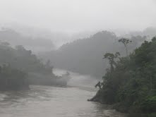
Inambari River
| Inambari River | |
|---|---|
 | |
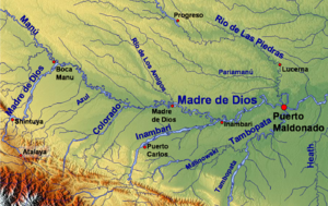
 The Madre de Dios watershed, including the lower Inambari | |
| Location | |
| Country | Peru |
| Physical characteristics | |
| Source | Andes |
| Mouth | Madre de Dios River |
| Length | 390 km (240 mi)[1] |
The Inambari River in southeastern Peru flows 210 miles (340 km) from the Cordillera Apolobamba in the Andes to the Madre de Dios River. The river spans the Puno and Madre de Dios regions.
Tributaries include the rivers Yanaqucha, Pukaramayu, Mancuari, Wila Uma, Blanco, San Bartolome, Yawarmayu and Winchusmayu. The Inambari passes through the towns of Cuyocuyo, Sandia and Massiapo, Pacaysuizo, Isilluma and St. Helena.
References
Rand McNally and Company (1980). Rand McNally Encyclopedia of World Rivers. Rand McNally. p. 336. ISBN 978-0-517-37909-7.
- ^ Ziesler, R.; Ardizzone, G.D. (1979). "Amazon River System". The Inland waters of Latin America. Food and Agriculture Organization of the United Nations. ISBN 92-5-000780-9. Archived from the original on 8 November 2014.
{{cite book}}:|archive-date=/|archive-url=timestamp mismatch; 21 October 2013 suggested (help)
12°43′S 69°44′W / 12.717°S 69.733°W
