
Inden, North Rhine-Westphalia
This article includes a list of references, related reading, or external links, but its sources remain unclear because it lacks inline citations. (May 2016) |
Inden | |
|---|---|
_COA.svg) Coat of arms | |
Location of Inden within Düren district 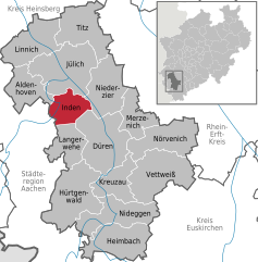 | |
| Country | Germany |
| State | North Rhine-Westphalia |
| Admin. region | Köln |
| District | Düren |
| Subdivisions | 7 |
| Government | |
| • Mayor | Ulrich Schuster |
| Area | |
| • Total | 35.92 km2 (13.87 sq mi) |
| Elevation | 106 m (348 ft) |
| Population (2023-12-31)[1] | |
| • Total | 7,608 |
| • Density | 210/km2 (550/sq mi) |
| Time zone | UTC+01:00 (CET) |
| • Summer (DST) | UTC+02:00 (CEST) |
| Postal codes | 52459 |
| Dialling codes | 02465 |
| Vehicle registration | DN |
| Website | www.inden.de |
Inden is a municipality in the district of Düren in the state of North Rhine-Westphalia, Germany. It is located on the river Inde, approx. 10 km north-west of Düren. In the area around Inden lignite is extracted in open-pit mines. Several hundreds of inhabitants have been resettled in the 1990s and 2000s because of these activities.[citation needed]
Towns and municipalities in Düren (district) | ||
|---|---|---|
 | ||
References
| International | |
|---|---|
| National | |
| Geographic | |
This Düren district location article is a stub. You can help Wikipedia by expanding it. |