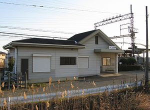
Ise-Nakahara Station
Ise-Nakahara Station 伊勢中原駅 | |
|---|---|
 Ise-Nakahara Station | |
| General information | |
| Location | 1455 Ureshinotsuyajo-cho, Matsusaka, Mie (三重県松阪市嬉野津屋城町1455) Japan |
| Operated by | Kintetsu Railway |
| Line(s) | Yamada Line |
| History | |
| Opened | 1930 |
| Previous names | Sangu-Nakahara (until 1940) |
| Passengers | |
| FY2010 | 183 daily |
Ise-Nakahara Station (伊勢中原駅, Ise-Nakahara-eki) is a railway station on the Yamada Line in Matsusaka, Mie Prefecture, Japan, operated by the private railway operator Kintetsu Railway. Ise-Nakahara Station is 3.0 rail kilometers from the terminus of the Yamada Line at Ise-Nakagawa Station.[1]
Station layout
Ise-Nakahara Station has two opposed side platforms. The station is unattended.
Platforms
| 1 | ■ Yamada Line | for Ujiyamada, Toba, Kashikojima |
| 2 | ■ Yamada Line | for Ise-Nakagawa, Kintetsu Nagoya, Osaka Namba, Kyoto |
Adjacent stations
| « | Service | » | ||
|---|---|---|---|---|
| Yamada Line | ||||
| Ise-Nakagawa | Local | Mie | ||
History
Ise-Nakahara Station opened on May 18, 1930 as Sangu-Nakahara Station (参急中原駅, Sangu-Nakahara-eki) on the Sangu Express Electric Railway. On March 15, 1941, the Sangu Express Electric Railway merged with Osaka Electric Railway to become a station on Kansai Express Railway's Yamada Line, at which time the station was renamed it its present name. [2] This line in turn was merged with the Nankai Electric Railway on June 1, 1944 to form Kintetsu.[2] The station has been unattended since February 1, 2005.
