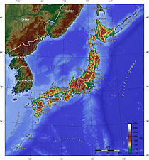
Japanese archipelago
Appearance

The Japanese Archipelago (日本列島, Nihon Rettō) which forms the country of Japan extends from north to south along the eastern coast of the Eurasian Continent, the western shore of the Pacific Ocean. The term Home Islands was used at the end of World War II to define the area of Japan to which its sovereignty and the constitutional rule of the Emperor would be restricted. The term is also commonly used today to distinguish the archipelago from Japan's colonies and other territories in the first half of the 20th century, but is not used in reference to the country as it exists today. The archipelago consists of more than 3000 islands, including the four Main Islands (in descending order from North to South):
