Jezava
| Jezava (Језава) | |
|---|---|
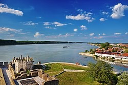
 The former confluence of Jezava and Danube | |
| Location | |
| Country | |
| Physical characteristics | |
| Mouth | |
• location | Great Morava |
• coordinates | 44°39′56″N 21°02′56″E / 44.6656°N 21.0490°E |
| Length | 47.5 km (29.5 mi) |
| Basin size | 692 km2 (267 sq mi)[1] |
| Discharge | |
| • average | 23 m3/s (810 cu ft/s) |
| Basin features | |
| Progression | Great Morava→ Danube→ Black Sea |
The Jezava (Serbian Cyrillic: Језава) is a river in central Serbia. Formerly a distributary of the Great Morava that flowed into the Danube in Smederevo at the Smederevo Fortress, its upper course was separated from the Great Morava by a dam after floods in 1897. In the 1970s the lower course of the Jezava was diverted into a new stream bed, leading to the Great Morava. The old bed of the Jezava in Smederovo has been retained for drainage of the urban area of Smederovo.[2] The Jezava drains an area of 692 km², belonging to the Black Sea drainage basin.[1]

Tributaries
- Ralja (Serbian Cyrillic: Раља)
- Konjska River (Serbian: Коњска река / Konjska reka, "Horse River")
See also
References
- ^ a b Velika Morava River Basin, ICPDR, November 2009, p. 2
- ^ Miladinović, Slobodan Đ.; Gavrilović, Ljiljana M. "Estimates of endangerment and protection from torrential floods on Smederovo territory" (PDF). Retrieved 2018-06-01.

