Jundiaí
Jundiaí | |
|---|---|
Municipality | |
| Município de Jundiaí | |
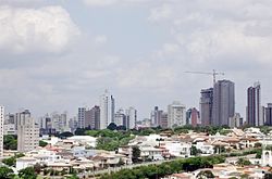
 Skyline | |
| Nickname: Grapeland | |
 Location of Jundiaí in the state of São Paulo | |
| Coordinates: 23°11′11″S 46°53′02″W / 23.18639°S 46.88389°W | |
| Country | |
| Region | Southeast |
| State | |
| Metropolitan Region | Jundiaí |
| Founded | December 14, 1655 |
| Government | |
| • Mayor | Luiz Fernando Machado (PSDB) |
| Area | |
| • Total | 431.207 km2 (166.490 sq mi) |
| Elevation | 762 m (2,497 ft) |
| Population (2015) | |
| • Total | 405,740 |
| • Density | 940.94/km2 (2,437.0/sq mi) |
| Time zone | UTC-3 (Brasilia Official Time) |
| • Summer (DST) | UTC-2 (Brazilian Daylight Saving Time) |
| Postal Code | 13200-000 |
| Area code | +55 11 |
| Website | [1] |
Jundiaí is a municipality in the Southeast Region of Brazil, located 57 kilometres (35 mi) north of São Paulo; Capital of state. The population of the city is 401,896 (2015 est.), in an area of 431.21 km².[1] The elevation is 761 m. The GDP of the city is U$16.6 billions (R$36.6 billions). The budget for 2013 is U$787 millions (R$1.63 billions), according to the official data of the City Hall, approved by the City Council of city.
History and Geography
The municipality was founded on December 14, 1655, when it was elevated to the category of village. Its first urbanization was carried out in 1657. Jundiaí has borders with Várzea Paulista, Campo Limpo Paulista, Franco da Rocha, Cajamar, Pirapora do Bom Jesus, Cabreúva, Itupeva, Louveira, Vinhedo, Itatiba and Jarinu.

The name of the town comes from the Tupi language, and it means the place of the jundiá ("fish with barbs", the Rhamdia quelen species).
Jundiaí has enjoyed a steep population growth, in large part fueled by a shift of residents from the megalopolis of São Paulo, seeking better living conditions.
Tourism
The Serra do Japi (Japi mountain range), situated southeast of the city, is a state park that has a natural reserve with one of the largest forested areas in the state of São Paulo, with beautiful landscapes and many opportunities for ecotourism, large hotel-farms and extreme sports.
The Jundiahy section is a historical area amongst the rivers Jundiai, Guapeva and Mato.It is an affluent neighborhood with fancy houses, gardens and a traditional small community business.
Sports
Paulista is the city's football (soccer) club. The team, which plays at Jayme Cintra Stadium, was the champion of Copa do Brasil 2005 (Cup of Brazil).
Transportation
The Jundiaí Airport serves the city and region for small airplanes. Jundiaí has a connection in the Jundiaí station with Companhia Paulista de Trens Metropolitanos (CPTM). It has a system of public transportation that currently costs R$3,00 (USD 1,45) for one way [2]. Most of the buses have wheelchair lifts and a few have monitors that broadcast videos about the city and education. The lines are all connected by terminais (terminals), what makes the users' traffic faster and cheaper since there is free circulation in the terminals to the linhas alimentadoras (feeding lines), which carry the passengers from the terminals to their respective destinations [3]. Yellow and reloadable electronic cards that replace cash may be used by regular users that perform a register; students have a blue card that charges only half instead of the ticket's full price; the elderly or disabled own a grey or green card which allows free admittance.
Twin towns and sister cities
Notable people
- Adriano Basso (1975), footballer
- Ana Carolina Reston Macan (1985–2006), -model
- Antônio de Queirós Teles, barão de Jundiaí (1789–1870), politician
- Antônio de Queirós Teles, conde do Parnaíba (1831–1888), politician, and president of São Paulo Province (1886–1887)
- Bianca Bin, actress
- Bianca Franceschinelli Bin Brandão, model and actress
- Cida Marques, model and actress
- Dalmo Gaspar
- Décio Pignatari (1927-2012), writer and poet
- Doni (1979), footballer
- Douglas Tufano, professor and linguist
- Eloísa Mafalda (1924), actress
- Edinaldo Batista Libânio (1979), footballer
- Fabio Zanon (1966), musician
- Gerson Sartori (1967), politician
- Jean Fercondini (1987), actor
- José Arnaldo de Oliveira (1963), sociologist
- Max Gehringer (1949), lawyer
- Nenê (1981), footballer
- Oscar Maroni Filho (1949), businessman
- Reginaldo (1983-), footballer
- Zenaide Oliveira (1985), athlete
- Rogério Moreira (1963), engineer
- Felipe Menegazzi Barbosa (1978), photographer


