
Königsegg
Lordship (Barony) of Königsegg Herrschaft (Freiherrschaft) Königsegg | |||||||||
|---|---|---|---|---|---|---|---|---|---|
| 1192–1806 | |||||||||
 Coat of arms
| |||||||||
| Status | State of the Holy Roman Empire | ||||||||
| Capital | Aulendorf | ||||||||
| Government | Principality | ||||||||
| Historical era | Middle Ages | ||||||||
• Established | 1192 | ||||||||
• Raised to barony | 1470 | ||||||||
1622 | |||||||||
• Raised to Imp. estate | 1629 | ||||||||
• Baronial line extinct; inherited by Aulendorf | 1663 | ||||||||
1804 | |||||||||
1806 | |||||||||
| Area | |||||||||
| 1806 | 160 km2 (62 sq mi) | ||||||||
| Population | |||||||||
• 1806 | 3,000 | ||||||||
| |||||||||
Königsegg was a German statelet in the southeastern part of the present State of Baden-Württemberg, Germany.
History
Königsegg emerged in 1192 as a Lordship, and was raised to a Barony in 1470. It was partitioned between itself, Königsegg-Aulendorf and Königsegg-Rothenfels in 1622, and was inherited by Königsegg-Aulendorf in 1663 with the extinction of the line.
In 1629, Königsegg was raised to an imperial estate and became a member of the College of the Counts of Swabia at the Reichstag. In 1804, Königsegg sold Rothenfels to Austria. In 1806, the Rheinbundakte mediatized the County of Königsegg to the Kingdom of Württemberg.
The Counts of Königsegg are still today residing at Königseggwald Castle, Swabia, and Halbturn Castle, Austria.
Geography
Königsegg was named after Königsegg Castle, located in Königsegg, today part of Guggenhausen. As of 1806, Königsegg consisted of two isolated parts, one around Königsegg, and one around Aulendorf. The county had no cities; its capital was Aulendorf. It was bordered by the County of Scheer, the Mainau Commandry of the Teutonic Order, the Abbacy of Weingarten, Fürstenberg, the Abbacy of Schussenried, the County of Waldburg and Austria. In 1806, Königsegg had an area of about 160 km2 (62 sq mi) and a population of 3000.

Princes of Königsegg
Lords of Königsegg (1192–1470)
- Berthold I of Fronhofen (1192–1209)
- Eberhard I (1209–1228)
- Unknown
- Eberhard II (1239–1268) with...
- Berthold II (1239–1251)
- Eberhard III (? – 1296)
- Ulrich I (? – 1300)
- John I (1300 – ?)
- Ulrich II (? – 1375) with...
- Henry with...
- Berthold III (? – 1370) with...
- Ulrich III
- Ulrich IV (? – 1444)
- John II
- John III
- Marquard (? – 1470)
Barons of Königsegg (1470–1663)
- Marquard (1470–1500)
- John IV (1500–1544)
- John Marquard (1544–1553) with...
- John James (1544–1567)
- Marquard IV (1567–1626) with...
- George II (1567–1622)
- John William (1626–1663)
-
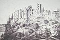
 Königsegg Castle near Guggenhausen
 -
 Rothenfels Castle near Immenstadt
 -
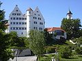 Aulendorf Castle
 -
 Königseggwald Castle
 -
 Halbturn Castle, Austria


References
- Köbler, Gerhard (2007). Historisches Lexikon der deutschen Länder (7th ed.). Munich. ISBN 978-3-406-54986-1.
{{cite book}}: CS1 maint: location missing publisher (link) Königsegg and Königsegg-Aulendorf articles.  Media related to Königsegg at Wikimedia Commons
47°57′15″N 9°38′20″E / 47.95417°N 9.63889°E
| International | |
|---|---|
| National | |
| People | |
This Baden-Württemberg location article is a stub. You can help Wikipedia by expanding it. |
This German history article is a stub. You can help Wikipedia by expanding it. |