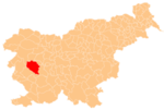
Kanji Dol
Appearance
Kanji Dol | |
|---|---|
| Coordinates: 45°53′59.19″N 14°2′55.55″E / 45.8997750°N 14.0487639°E | |
| Country | |
| Traditional region | Littoral |
| Statistical region | Gorizia |
| Municipality | Idrija |
| Area | |
| • Total | 3.63 km2 (1.40 sq mi) |
| Elevation | 897.3 m (2,943.9 ft) |
| Population (2015) | |
| • Total | 11 |
| • Density | 3/km2 (8/sq mi) |
| [1] | |
Kanji Dol (pronounced [ˈkaːnji ˈdoːu̯]; German: Kanidol[2]) is a dispersed settlement in the hills south of Črni Vrh in the Municipality of Idrija in the traditional Littoral region of Slovenia. The population no longer had any permanent residents according to the 2002 census, but has been repopulated in recent years.[1]
References
- ^ a b "Kanji Dol, Idrija". Place Names. Statistical Office of the Republic of Slovenia. Retrieved 22 October 2015.
- ^ Leksikon občin kraljestev in dežel zastopanih v državnem zboru, vol. 6: Kranjsko. 1906. Vienna: C. Kr. Dvorna in Državna Tiskarna, p. 124.
External links


