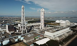
Kawagoe Power Station
| Kawagoe Power Station | |
|---|---|
 | |
 | |
| Country | |
| Coordinates | 35°00′25″N 136°41′20″E / 35.0069°N 136.6889°E |
| Status | Operational |
| Commission date | 1997 |
| Owner(s) | CEP |
| Operator(s) | |
| Power generation | |
| Nameplate capacity |
|
| External links | |
| Commons | Related media on Commons |
Kawagoe Power Station (川越火力発電所, Kawagoe karyokuhatsudensho) is a large gas-fired power station in Kawagoe, Mie, Japan. The facility operates at an installed capacity of 4,802 MW, making it the largest power station of its kind.[1][2][3]
