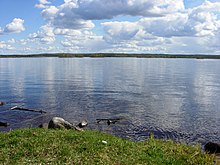
Kemijoki
Appearance
This article needs additional citations for verification. (October 2015) |


Kemijoki (Swedish: Kemi älv, Northern Sami: Giemajohka), with its 550 km (340 mi) length, is the longest river in Finland. It runs through Kemijärvi and Rovaniemi before reaching the Gulf of Bothnia at Kemi.[1]
At Rovaniemi the Ounasjoki river merges with Kemijoki.
The first hydroelectric plant on Kemijoki was constructed in 1949 at Isohaara. A total of 15 power plants have been constructed so far. The plants are owned by Kemijoki Oy and Pohjolan Voima Oy. In 2003 the plants produced a total of 4.3 TWh, which was about 34.5% of Finland's total hydroelectric production.
See also
References
External links
![]() Media related to Kemijoki at Wikimedia Commons
Media related to Kemijoki at Wikimedia Commons
65°46′N 24°27′E / 65.77°N 24.45°E
