Kenai River
| Kenai River | |
|---|---|
 | |
| Physical characteristics | |
| Mouth | Cook Inlet |
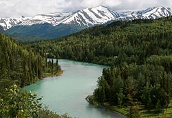
The Kenai River is a river in the Kenai Peninsula of south central Alaska. It runs 82 miles (132 km) westward from Kenai Lake in the Kenai Mountains, through the Kenai National Wildlife Refuge and Skilak Lake to its outlet into the Cook Inlet of the Pacific Ocean near Kenai and Soldotna, Alaska.
Geography
The Kenai River is a meltwater river that drains the central Kenai Peninsula region. Its source is the Kenai Lake. Near Cooper Landing, the lake narrows to form the river. About 12 miles (19 km) from the lake, the river passes through Kenai Canyon for about 2 miles (3.2 km) of fast-flowing whitewater rapids. 17.3 miles (27.8 km) from Kenai Lake, the river enters Skilak Lake. The Kenai to Skilak section is commonly referred to as the "Upper River". The 19.5 miles (31.4 km) portion from Skilak Lake downstream to the Sterling Highway bridge near Soldotna is known as "Mid-River". The final 21 miles (34 km) from the bridge to the mouth at Cook Inlet is known as the "Lower River", where the flow is much gentler. The final 12 miles (19 km) are greatly influenced by changing tides.[1]
Fish

The Kenai River is the most popular sport fishing destination in Alaska, particularly for King or Chinook salmon.[1][2][3][4] Each year there are two runs each of king salmon, silver salmon, red salmon, plus a run of pink salmon every other year. The world record king salmon, which weighed about 44 kg (97 lb), was caught in the Kenai River in 1985. The Kenai is also the home of trophy size rainbow trout and Dolly Varden. Stretching to sizes over 76.2cm (30 inches). Occasionally there will be reports of catching of "Steelhead"(Sea-run Trout).
The king salmon fishery is not as prolific as in other Alaskan rivers, but the Kenai is known for its large fish. A typical king in the second run, beginning in mid-July, weighs 40–85 pounds (18–23 kg), with considerably larger specimens not uncommon. The "Lower Kenai" is notorious for its run and sizes of its king salmon.
The silver salmon runs occur in early August and late September. The September run is favored by local anglers due to the larger size of the silver salmon.
The red salmon runs are in late-June (bluebacks) and late-July. Reds are considered the premier salmon for eating, canning, and smoking.
The pink salmon run occurs in even numbered years only. These fish are considered pests by many anglers because they interfere with catching other species and because, by the time they reach inland freshwater, their meat may be soft and oily compared to other species. Nevertheless, using super-light tackle (e.g., 4-pound test), angling for pinks can be a real treat. On a heavy day, even a casual fisher might catch several dozen of the species.
Other wildlife

Along with Kenai's fish, the Kenai River area is home to other wildlife, including moose, bears, and multiple species of birds. In the spring, Beluga whales have been seen as far as six miles upstream from the mouth of the river to feed on schools of spawning Hooligan fish.
Management
Over 105 linear miles the river and lakes are managed by the Alaska Department of Natural Resources as the Kenai River Special Management Area, from four miles inland of the river mouth at Cook Inlet, to 82 miles upstream. Adjacent to the management district are fifteen different state parks.[5]
See also
External links
- Stock assessment of rainbow trout in the upper Kenai River, Alaska, in 2001 / by Bruce E. King and Jeffery A. Breakfield. Hosted by Alaska State Publications Program.
References
- ^ a b "The Kenai River" (PDF). Alaska Department of Fish and Game.
- ^ "About KRSA". Kenai River Sportsfishing Association.
- ^ "Kenai River Facts". Mystic Fishing.
- ^ "Boat Waves on Johnson Lake and Kenai River, Alaska. - Final rept". U.S. Department of Commerce.
- ^ "Kenai River Special Management Area". Alaska Department of Natural Resources.
