
Kenyon Bridge
Kenyon Bridge | |
.jpg) | |
  | |
| Location | Off NH 12A at Mill Brook and Town House Rd., Cornish City, New Hampshire |
|---|---|
| Coordinates | 43°28′0″N 72°21′3″W / 43.46667°N 72.35083°W |
| Area | 0.5 acres (0.20 ha) |
| Built | 1882 |
| Architect | Tasker, James |
| Architectural style | Multiple Kingpost Truss |
| NRHP reference No. | 78000223[1] |
| Added to NRHP | May 22, 1978 |
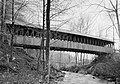
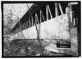
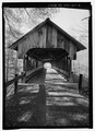
The Kenyon Bridge, also known as the Blacksmith Shop Bridge, is a historic covered bridge in Cornish, New Hampshire, United States.
History
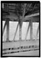
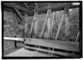
Now closed to vehicular traffic, it formerly carried Town House Road over Mill Brook, just east of its junction with Center Street. The multiple kingpost truss bridge was built in 1882 by James Frederick Tasker (1826–1903), and is 96 feet (29 m) long and 14.5 feet (4.4 m) wide, with a roadbed 90 feet (27 m) long and 13 feet (4.0 m) wide. The bridge rests on dry-laid stone abutments. The bridge is sheltered by a sheet metal roof, and has vertical plank siding covering the lower 1/3 of the trusses. Each truss consists of 28 panel sections between 29 posts.[2]
The bridge was listed on the National Register of Historic Places in 1978.[1]
See also
Other covered bridges in Cornish
Covered bridges in nearby West Windsor, Vermont
Other bridges elsewhere
Images
- Structural design of the Kenyon Bridge
-

-

-
-

-
-

-

-

-
-

-
-
-

-


References
- ^ a b "National Register Information System". National Register of Historic Places. National Park Service. July 9, 2010.
- ^ "NRHP nomination for Kenyon Bridge". National Park Service. Retrieved 2014-07-05.
External links
| Topics |  | |
|---|---|---|
| Lists by county | ||
| Other lists | ||
- Road bridges on the National Register of Historic Places in New Hampshire
- Bridges completed in 1882
- Bridges in Sullivan County, New Hampshire
- National Register of Historic Places in Sullivan County, New Hampshire
- Cornish, New Hampshire
- Road bridges in New Hampshire
- Wooden bridges in New Hampshire
- Covered bridges in New Hampshire
- King post truss bridges in the United States
- New Hampshire Registered Historic Place stubs