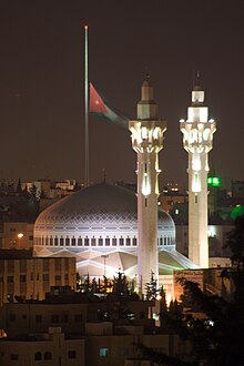
King Abdullah I Mosque
Appearance
| King Abdullah I Mosque | |
|---|---|
 | |
| Religion | |
| Affiliation | Islam |
| Ownership | Government of Jordan |
| Location | |
| Location | Amman - Jordan |
| Administration | Ministry of Endowments, Islamic Affairs and Holy Places |
| Architecture | |
| Type | Mosque |
| Style | Islamic architecture |
| Date established | 1982 |
| Specifications | |
| Capacity | 10000 worshippers |
| Site area | 18,000 m2 (190,000 sq ft) |
| Website | |
| www | |
The King Abdullah I Mosque in Amman, Jordan was built between 1982 and 1989. It is capped by a magnificent blue mosaic dome beneath which 3,000 Muslims may offer prayer.
Tourists are allowed to visit. Men must have long trousers on and women must cover their heads, arms and legs. A hooded gown is provided free of charge for this purpose.
External links
31°57′42″N 35°54′47″E / 31.9616°N 35.9131°E


