
Kiro, Kansas
Kiro, Kansas | |
|---|---|
Census-designated place | |
 | |
| Country | United States |
| State | Kansas |
| County | Shawnee |
| Time zone | UTC-6 (Central (CST)) |
| • Summer (DST) | UTC-5 (CDT) |
| Area code | 785 |
Kiro is an unincorporated community and census-designated place in Shawnee County, Kansas, United States.
39°05′49″N 95°47′52″W / 39.09694°N 95.79778°W
Municipalities and communities of Shawnee County, Kansas, United States | ||
|---|---|---|
| Cities | 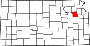 | |
| CDPs | ||
| Unincorporated communities | ||
| Ghost town | ||
| Townships | ||
| Footnotes | ‡This community also has portions in an adjacent county or counties. | |