Kohori Kofun Cluster
古保利古墳群 | |
| Location | Nagahama, Shiga, Japan |
|---|---|
| Region | Kansai region |
| Coordinates | 35°28′41.83″N 136°11′36.2″E / 35.4782861°N 136.193389°E |
| Type | Kofun cluster |
| History | |
| Founded | 3rd to 6th century AD |
| Periods | Kofun period |
| Site notes | |
| Public access | Yes (no public facilities) |
The Kohori Kofun Cluster (古保利古墳群) is a group of Kofun to early Nara period burial mound located in the Takatsuki neighborhood of the city of Nagahama, Shiga Prefecture in the Kansai region of Japan. It was designated a National Historic Site of Japan in 2003.[1] It is the largest kofun cluster in Shiga Prefecture.
Overview
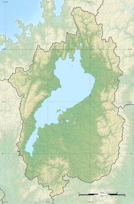
[edit]The Kohori Kofun Cluster extends along a three kilometer ridge running north-to-south on Nishinoyama hill facing Shiotsu Bay at the northern end of Lake Biwa. The ridge has an elevation of 200 to 240 meters, and is 100 meters above the surface of Lake Biwa. The cluster consists of seven keyhole-shaped zenpō-kōen-fun (前方後円墳), having one square end and one circular end, when viewed from above, eight "two conjoined rectangles" type (zenpō-kōhō-fun (前方後方墳)), one scallop-shaped hotategai-gata-fun (帆立貝型墳), 79 circular-type (empun (円墳)) and 37 square-type (hōfun (方墳)) for a total of 132 tumuli.[2] These have been divided by archaeologists into six groupings labelled "Group A" through "Group F" during a survey in 1965. The largest is the Nishinoyama Kofun, which has a total length of 90 meters. Most of the circular and square mounds are from 10 to 20 meters in diameter or on each side, with the largest at no more the 30 meters.
The larger zenpō-kōen-fun and zenpō-kōhō-fun are estimated to date from the early Kofun period, or around the beginning of the 3rd century AD. This has been verified by an excavation of the Komatsu Kofun from 1998 to 2000, from which numerous grave goods were recovered, including much earthenware, bronze mirrors and copper and iron products. No haniwa have been recovered from any of the tumuli in the cluster, but fukiishi have been found on some of the earlier tombs. The smaller circular and square tombs date to as late as the early 7th century AD, or into the early Nara period.[2]
The site is unusual not only in the number of tumuli, but in the variety of styles. In addition, although it is on the major highway from the Yamato region to the Sea of Japan, the kofun are visible only from Lake Biwa, indicating that the builders had a strong connection to water transportation on the lake. The site is about ten minutes by car from Takatsuki Station on the JR West Hokuriku Main Line.[2]
| Branch | Kofun name | Coordinates | Shape | Scale | Construction time | Remarks | |
|---|---|---|---|---|---|---|---|
| Branch # | Common name | ||||||
| A | A-1 | 深谷古墳 | 35°28′45.08″N 136°11′27.90″E / 35.4791889°N 136.1910833°E | zenpō-kōen-fun | |||
| A-2 | 西野山古墳 | 35°28′41.83″N 136°11′36.20″E / 35.4782861°N 136.1933889°E | zenpō-kōen-fun | length 90m | largest in cluster | ||
| A-3 | A-3号墳 | enpun | dia 15m | late Kofun period | Confirmation survey | ||
| A-5 | 巳ノ脇古墳 | ||||||
| B | B-1 | ヘソ岩古墳 | 35°28′25.94″N 136°11′40.26″E / 35.4738722°N 136.1945167°E | hotategai-gata | length 21m | ||
| B-6 | 小松古墳 | 35°28′20.82″N 136°11′38.95″E / 35.4724500°N 136.1941528°E | zenpō-kōhō-fun | length 60m | early Kofun period | oldest in cluster Confirmation survey grave goods | |
| B-10 | 木戸古墳 | enpun | dia 25m | early Kofun period | Confirmation survey | ||
| B-16 | 木戸越古墳 | 35°28′12.23″N 136°11′40.95″E / 35.4700639°N 136.1947083°E | zenpō-kōen-fun | ||||
| C | C-10 | 西山古墳 | |||||
| C-16 | 大浦古墳 | 35°28′3.74″N 136°11′44.55″E / 35.4677056°N 136.1957083°E | zenpō-kōhō-fun | ||||
| C-17 | 野瀬古墳 | enpun | dia 30m | early Kofun period | Confirmation survey | ||
| C-20 | C-20号墳 | hōfun | length 22m | mid Kofun period | Confirmation survey | ||
| C-22 | C-22号墳 | enpun | final Kofun period | Confirmation survey | |||
| D | D-1 | 寺ヶ浦古墳 | 35°27′57.66″N 136°11′46.01″E / 35.4660167°N 136.1961139°E | zenpō-kōen-fun | |||
| D-2 | 臼ヶ谷古墳 | 35°27′54.58″N 136°11′47.56″E / 35.4651611°N 136.1965444°E | zenpō-kōhō-fun | ||||
| D-6 | 堂山古墳 | ||||||
| D-7 | 堂谷古墳 | ||||||
| D-10 | 南山古墳 | ||||||
| D-24 | 井ノ浦古墳 | ||||||
| D-41 | 北谷古墳 | 35°27′40.80″N 136°11′56.67″E / 35.4613333°N 136.1990750°E | zenpō-kōhō-fun | ||||
| D-42 | 黒見古墳 | 35°27′38.69″N 136°11′58.03″E / 35.4607472°N 136.1994528°E | zenpō-kōen-fun | ||||
| E | E-1 | 上大谷古墳 | 35°27′34.67″N 136°12′2.31″E / 35.4596306°N 136.2006417°E | zenpō-kōhō-fun | |||
| E-5 | 岩屋古墳 | 35°27′30.58″N 136°12′3.92″E / 35.4584944°N 136.2010889°E | zenpō-kōhō-fun | ||||
| E-7 | 蜂谷古墳 | ||||||
| E-9 | 熊野山古墳 | 35°27′26.71″N 136°12′5.04″E / 35.4574194°N 136.2014000°E | zenpō-kōhō-fun | ||||
| E-14 | 屋ヶ谷古墳 | 35°27′23.14″N 136°12′7.32″E / 35.4564278°N 136.2020333°E | zenpō-kōhō-fun | ||||
| E-15 | 大谷古墳 | 35°27′20.72″N 136°12′9.13″E / 35.4557556°N 136.2025361°E | zenpō-kōen-fun | ||||
| F | F-1 | 旭山古墳 | 35°27′16.20″N 136°12′11.97″E / 35.4545000°N 136.2033250°E | zenpō-kōen-fun | |||
See also
[edit]References
[edit]- ^ "古保利古墳群" [Kohori Kofun Cluster] (in Japanese). Agency for Cultural Affairs. Retrieved August 20, 2020.
- ^ a b c Isomura, Yukio; Sakai, Hideya (2012). (国指定史跡事典) National Historic Site Encyclopedia. 学生社. ISBN 4311750404.(in Japanese)
External links
[edit]- Shiga Prefecture Department of Education (in Japanese)


