
Kolga-Aabla
Kolga-Aabla | |
|---|---|
Village | |
 The village road | |
| Country | |
| County | Harju County |
| Parish | Kuusalu Parish |
| Time zone | UTC+2 (EET) |
| • Summer (DST) | UTC+3 (EEST) |
Kolga-Aabla is a village in Kuusalu Parish, Harju County in northern Estonia, on the territory of Lahemaa National Park. It is located on the Juminda Peninsula.
-
 Entrance to Kolga-Aabla from Pedaspea side.
 -
 Bus stop in Kolga-Aabla
 -
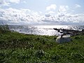 Old harbour
 -
 Former factory


59°34′04″N 25°31′44″E / 59.56778°N 25.52889°E
This Harju County location article is a stub. You can help Wikipedia by expanding it. |