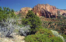
Kolob Canyons


Kolob Canyons is the northwest section of Zion National Park of Utah, United States. The Kolob Canyons are part of the Colorado Plateau region of the park and are noted for their colorful beauty and diverse landscape. This part of Zion National Park is accessed by a park road about 20 miles south of Cedar City, Utah off Interstate 15.
In 1847, Mormon farmers from the Salt Lake area became the first people of European descent to settle the Virgin River region.[1] In 1851, the Parowan and Cedar City, Utah areas were settled by Mormons who used the Kolob Canyons area for timber, and for grazing cattle, sheep, and horses.[2] They prospected for mineral deposits, and diverted Kolob water to irrigate crops in the valley below. Mormon settlers named the area Kolob—in Mormon scripture, the heavenly place nearest the residence of God.[3]
See also
Notes
- ^ Harris, Ann G.; Tuttle, Esther; Tuttle, Sherwood D. (1997), "2: Zion National Park, Southwest Utah", Geology of National Parks (5th ed.), Iowa: Kendall/Hunt Publishing, pp. 28–42, ISBN 0-7872-5353-7
- ^ Arrington, Leonard J. (1994), "Colonization of Utah", Utah History Encyclopedia, Salt Lake City, Utah: University of Utah Press, retrieved 2012-12-06
- ^ NPS contributors (2009), 2009 Centennial Newspaper, Washington, D.C.: National Park Service, retrieved 2012-12-06
{{citation}}:|author=has generic name (help)
External links
![]() Media related to Kolob Canyons at Wikimedia Commons
Media related to Kolob Canyons at Wikimedia Commons
37°24′N 113°12′W / 37.4°N 113.2°W
