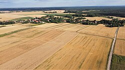
Konary, Wołów County
Konary | |
|---|---|
Village | |
 | |
| Coordinates: 51°24′44″N 16°33′28″E / 51.41222°N 16.55778°E | |
| Country | |
| Voivodeship | Lower Silesian |
| County | Wołów |
| Gmina | Wińsko |
| First mentioned | 1202 |
| Time zone | UTC+1 (CET) |
| • Summer (DST) | UTC+2 (CEST) |
| Vehicle registration | DWL |
| Voivodeship road | |
Konary [kɔˈnarɨ] is a village in the administrative district of Gmina Wińsko, within Wołów County, Lower Silesian Voivodeship, in south-western Poland.
It lies approximately 8 kilometres (5 mi) south-west of Wińsko, 10 kilometres (6 mi) north-west of Wołów, and 47 kilometres (29 mi) north-west of the regional capital Wrocław.
History
[edit]The village was first mentioned as Uconar in a document of Cyprian, bishop of Wrocław from 1202, when it was part of fragmented Piast-ruled Poland.[1] The name of the village is of Polish origin and comes either from the word konar which means "branch" or from the word koń which means "horse".[2][3]
Under Prussian rule, the world's first factory for extracting sugar from sugar beets was opened in 1802 in Konary (then known as Kunern).[4]
References
[edit]- ^ Grünhagen, Colmar (1884). Codex Diplomaticus Silesiae (in German). Vol. 7. Josef Max & Comp. p. 68.
- ^ Damrot, Konstanty (1896). Die älteren Ortsnamen Schlesiens, ihre Entstehung und Bedeutung. Mit einem Anhange über die schlesisch-polnischen Personennamen. Beiträge zur schlesischen Geschichte und Volkskunde (in German). Verlag von Felix Kasprzyk. p. 172.
- ^ Adamy, Heinrich (1888). Die schlesischen Ortsnamen, ihre Entstehung und Bedeutung. Ein Bild aus der Vorzeit (in German). Verlag von Priebatsch's Buchhandlung. p. 35.
- ^ Langer, R.H.M.; Hill, G.D. (1991), Agricultural Plants, Cambridge University, pp. 197–199, ISBN 0-521-40563-7

