
Kosciusko, Mississippi
Kosciusko, Mississippi | |
|---|---|
 Welcome sign located on Mississippi Highway 12 | |
 Location of Kosciusko, Mississippi | |
| Coordinates: 33°3′29″N 89°35′18″W / 33.05806°N 89.58833°W | |
| Country | United States |
| State | Mississippi |
| County | Attala |
| Area | |
| • Total | 7.6 sq mi (19.6 km2) |
| • Land | 7.5 sq mi (19.5 km2) |
| • Water | 0.008 sq mi (0.02 km2) |
| Elevation | 479 ft (146 m) |
| Population (2010) | |
| • Total | 7,402 |
| • Estimate (2016)[1] | 7,139 |
| • Density | 980/sq mi (380/km2) |
| Time zone | UTC-6 (Central (CST)) |
| • Summer (DST) | UTC-5 (CDT) |
| ZIP code | 39090 |
| Area code | 662 |
| FIPS code | 28-38320 |
| GNIS feature ID | 0672213 |
| Website | www |
Kosciusko /ˌkɒsiˈʌskoʊ/ is a city in Attala County, Mississippi, United States. The population was 7,402 at the 2010 census.[2] It is the county seat of Attala County.[3]
Kosciusko is located on the Natchez Trace Parkway, northeast of Jackson. It is named for the U.S. and Polish-Lithuanian general Tadeusz Kościuszko, who assisted United States military efforts during the American Revolution.[4] However, the Anglicized name of the city omits the "z". Kosciusko was originally named Red Bud Springs for one of three natural springs that were present in the city.
Kosciusko was the home of Magnolia Bible College, and the birthplace for several notable people, including Oprah Winfrey and James Meredith.
Geography
Kosciusko is located at 33°3′29″N 89°35′18″W / 33.05806°N 89.58833°W (33.058108, -89.588301),[5] along the Yockanookany River.
According to the United States Census Bureau, the city has a total area of 7.6 square miles (20 km2), of which 7.5 square miles (19 km2) is land and 0.13% is water.
Demographics
| Census | Pop. | Note | %± |
|---|---|---|---|
| 1890 | 1,394 | — | |
| 1900 | 2,078 | 49.1% | |
| 1910 | 2,385 | 14.8% | |
| 1920 | 2,258 | −5.3% | |
| 1930 | 3,237 | 43.4% | |
| 1940 | 4,291 | 32.6% | |
| 1950 | 6,753 | 57.4% | |
| 1960 | 6,800 | 0.7% | |
| 1970 | 7,266 | 6.9% | |
| 1980 | 7,415 | 2.1% | |
| 1990 | 6,986 | −5.8% | |
| 2000 | 7,372 | 5.5% | |
| 2010 | 7,402 | 0.4% | |
| 2016 (est.) | 7,139 | [1] | −3.6% |
| U.S. Decennial Census[6] | |||
As of the census[7] of 2000, there were 7,372 people, 2,885 households, and 1,906 families residing in the city. The population density was 977.8 people per square mile (377.5/km²). There were 3,174 housing units at an average density of 421.0 per square mile (162.5/km²). The racial makeup of the city was 53.66% White, 44.57% African American, 0.16% Native American, 0.46% Asian, 0.60% from other races, and 0.54% from two or more races. Hispanic or Latino of any race were 1.06% of the population.
There were 2,885 households out of which 31.7% had children under the age of 18 living with them, 40.2% were married couples living together, 21.9% had a female householder with no husband present, and 33.9% were non-families. 31.2% of all households were made up of individuals and 17.5% had someone living alone who was 65 years of age or older. The average household size was 2.43 and the average family size was 3.04.
In the city, the population was spread out with 26.2% under the age of 18, 9.5% from 18 to 24, 23.9% from 25 to 44, 19.8% from 45 to 64, and 20.6% who were 65 years of age or older. The median age was 37 years. For every 100 females, there were 82.7 males. For every 100 females age 18 and over, there were 77.1 males.
The median income for a household in the city was $21,737, and the median income for a family was $29,000. Males had a median income of $27,423 versus $16,487 for females. The per capita income for the city was $13,478. About 20.9% of families and 24.2% of the population were below the poverty line, including 31.9% of those under age 18 and 20.1% of those age 65 or over.
Education
The city of Kosciusko is served by the Kosciusko School District.
Blues Highway
As of April 2009, Kosciusko is featured as part of the Mississippi Blues Trail.[8]
Notable people
- Dave Barnes, singer-songwriter and musician (Razor & Tie)
- Billy Ray Bates, professional basketball player, was born in Kosciusko.[9]
- Eva Webb Dodd, founder, Delta Gamma Fraternity
- Clarence Harmon, NFL player
- James Meredith, civil rights figure
- Charlie Musselwhite, blues harmonica player and bandleader was born in Kosciusko in 1944.
- Topher Payne, playwright[10]
- Oprah Winfrey, television host/personality, who lived in Kosciusko up to age six
- Marc Woodard, NFL player
Climate
The climate in this area is characterized by hot, humid summers and generally mild to cool winters. According to the Köppen Climate Classification system, Kosciusko has a humid subtropical climate, abbreviated "Cfa" on climate maps.[11]
The data below are from the WRCC, compiled from 1893 to the time this chart was created (July 2018).[12]
| Climate data for Kosciusko, MS | |||||||||||||
|---|---|---|---|---|---|---|---|---|---|---|---|---|---|
| Month | Jan | Feb | Mar | Apr | May | Jun | Jul | Aug | Sep | Oct | Nov | Dec | Year |
| Record high °F (°C) | 85 (29) |
85 (29) |
92 (33) |
98 (37) |
102 (39) |
109 (43) |
108 (42) |
109 (43) |
109 (43) |
98 (37) |
89 (32) |
84 (29) |
109 (43) |
| Mean daily maximum °F (°C) | 55.5 (13.1) |
58.8 (14.9) |
67.5 (19.7) |
75.5 (24.2) |
82.5 (28.1) |
89.4 (31.9) |
91.5 (33.1) |
91.6 (33.1) |
87.2 (30.7) |
77.3 (25.2) |
65.9 (18.8) |
57.0 (13.9) |
75.0 (23.9) |
| Mean daily minimum °F (°C) | 33.6 (0.9) |
35.7 (2.1) |
42.8 (6.0) |
50.7 (10.4) |
58.8 (14.9) |
66.4 (19.1) |
69.4 (20.8) |
68.6 (20.3) |
62.6 (17.0) |
50.1 (10.1) |
40.8 (4.9) |
34.8 (1.6) |
51.2 (10.7) |
| Record low °F (°C) | −14 (−26) |
−8 (−22) |
10 (−12) |
24 (−4) |
36 (2) |
41 (5) |
53 (12) |
50 (10) |
37 (3) |
20 (−7) |
12 (−11) |
0 (−18) |
−14 (−26) |
| Average precipitation inches (mm) | 5.36 (136) |
5.27 (134) |
5.99 (152) |
5.35 (136) |
4.68 (119) |
3.66 (93) |
5.00 (127) |
3.76 (96) |
3.33 (85) |
3.19 (81) |
4.45 (113) |
5.41 (137) |
55.45 (1,409) |
| Average snowfall inches (cm) | 1.2 (3.0) |
0.3 (0.76) |
0.3 (0.76) |
0 (0) |
0 (0) |
0 (0) |
0 (0) |
0 (0) |
0 (0) |
0 (0) |
0 (0) |
0.4 (1.0) |
2.2 (5.52) |
| Source: https://wrcc.dri.edu/cgi-bin/cliMAIN.pl?ms4776 | |||||||||||||
Gallery
-
 Attala County Courthouse
 -
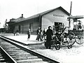 Illinois Central Depot in Kosciusko, 1920


References
- ^ a b "Population and Housing Unit Estimates". Retrieved June 9, 2017.
- ^ "Geographic Identifiers: 2010 Demographic Profile Data (G001): Kosciusko city, Mississippi". U.S. Census Bureau, American Factfinder. Retrieved June 19, 2013.
- ^ "Find a County". National Association of Counties. Archived from the original on 2011-05-31. Retrieved 2011-06-07.
{{cite web}}: Unknown parameter|deadurl=ignored (|url-status=suggested) (help) - ^ Gannett, Henry (1905). The Origin of Certain Place Names in the United States. Government Printing Office. p. 177.
- ^ "US Gazetteer files: 2010, 2000, and 1990". United States Census Bureau. 2011-02-12. Retrieved 2011-04-23.
- ^ "Census of Population and Housing". Census.gov. Archived from the original on May 12, 2015. Retrieved June 4, 2015.
{{cite web}}: Unknown parameter|deadurl=ignored (|url-status=suggested) (help) - ^ "American FactFinder". United States Census Bureau. Retrieved 2008-01-31.
- ^ Dees, Leslie N. (January 23, 2009) Kosciusko to be featured on Blues Trail. The Star Herald
- ^ "NBA Players: Billy Ray Bates Profile and Basic Stats". Retrieved 28 February 2017.
- ^ Topher Payne - Mississippi Arts & Entertainment Center Archived 2015-12-10 at the Wayback Machine. Msarts.org (2013-11-21). Retrieved on 2015-12-25.
- ^ "Kosciusko, Mississippi Köppen Climate Classification (Weatherbase)". Weatherbase. Retrieved 21 July 2015.
- ^ "KOSCIUSKO, MISSISSIPPI - Climate Summary". wrcc.dri.edu. Retrieved 2018-07-24.
External links
Municipalities and communities of Attala County, Mississippi, United States | ||
|---|---|---|
| Cities |  | |
| Towns | ||
| Unincorporated communities | ||
| Ghost towns | ||
| Indian reservation | ||
| Footnotes | ‡This populated place also has portions in an adjacent county or counties | |