
Koudekerke
Koudekerke | |
|---|---|
Town | |
 Coat of arms | |
 | |
 The town centre (dark green) and the statistical district (light green) of Koudekerke in the municipality of Veere. | |
| Coordinates: 51°29′51″N 3°33′10″E / 51.49750°N 3.55278°E | |
| Country | Netherlands |
| Province | Zeeland |
| Municipality | Veere |
| Population (1 January 2018) | |
| • Total | 3,419 |
| Demonym | Koudekerkenaar |
| Time zone | UTC+1 (CET) |
| • Summer (DST) | UTC+2 (CEST) |
| Postal code | 4371 |
| Dialing code | 0118 |
Koudekerke (Zeelandic: Koukerke) is a town in the region of Walcheren in the Dutch province of Zeeland. It is a part of the municipality of Veere. According to the 2018 census, the town has a population of 3419, making it the largest settlement in Veere[1]. The built-up area of the town was 0.55 km², and contained 1133 residences.[2]
Images
-
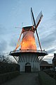 Windmill "De Lelie"
 -
 Farmhouse at Dishoekseweg
 -

-
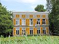 Huis Moesbosch
 -
 German Bunker from WWII in Koudekerke


See also
References
- ^ https://www.veere.nl/bestuur/feiten-en-cijfers_47605
- ^ Statistics Netherlands (CBS), Bevolkingskernen in Nederland 2001 [1]. (Statistics are for the continuous built-up area).