
Kuiseb River
23°07′S 14°32′E / 23.117°S 14.533°E
| Kuiseb River | |
|---|---|
 The Kuiseb River during rain season | |
 Satellite image of the Kuiseb River | |
| Location | |
| Country | Namibia |
| Region | Khomas / Walvis Bay |
| Physical characteristics | |
| Source | |
| • location | Windhoek |
| Mouth | |
• location | Walvis Bay |
| Length | 300 mi (480 km) |
The Kuiseb River in Namibia flows from the Khomas highlands west of Windhoek to Walvis Bay. The Kuiseb is an ephemeral river with a mean run-off of roughly 20 million cubic metres per annum (710×106 cu ft/a).[1]
It is bordered on one side by some of the tallest sand dunes in the world, and on the other by barren rock. The red sand dunes south of the river reach heights over 150 meters. The prevailing winds blow the dunes northward, but their movement is blocked by the river. In the process, so much sand and silt is deposited in the Kuiseb that it only reaches the sea while it is in flood. Friedenau Dam, built in 1972, is located on the river.[2]
-
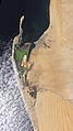 Natural-colour satellite image of the Kuiseb River.
 -
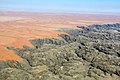 Kuiseb River from bird's eye view (2017)


See also
References
- ^ "ELECTIONS 2010: Erongo regional profile". New Era. 16 November 2010. Archived from the original on 6 September 2012.
{{cite news}}: Unknown parameter|deadurl=ignored (|url-status=suggested) (help) - ^ Friedenau at NamWater
- The original entry was from the NASA Earth Observatory [1]
External links
Wikimedia Commons has media related to Kuiseb River.
- Kuiseb River at the Encyclopædia Britannica
- NASA Earth Explorer page
- PhD Dissertation at the Helmholtz Centre for Environmental Research - UFZ