Kvarken

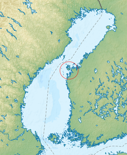
Kvarken (Swedish Kvarken or Norra Kvarken (as opposed to South Kvarken), Finnish Merenkurkku) is the narrow region in the Gulf of Bothnia separating the Bothnian Bay (the inner part of the gulf) from the Bothnian Sea. The distance from Swedish mainland to Finnish mainland is around 80 km (50 mi) while the distance between the outmost islands is only 25 km (16 mi). The water depth in the Kvarken region is only around 25 metres (82 ft). The region also has an unusual rate of land rising at about 10 mm (0.39 inches) a year.
On the Finnish side of Kvarken, there is a large archipelago, the Kvarken Archipelago, which includes the large islands Replot, Björkö and a large number of smaller islands. Most of it is belongs to the municipality of Korsholm. Most of the small islands are inhabited. The archipelago is smaller on the Swedish side of the region, and the islands have much steeper shores. The Kvarken region was historically important also, because mail was delivered across Kvarken when the sea was completely frozen from the Swedish to the Finnish coast. This mail route was used frequently during the period of Swedish rule.
In the group of islands in the “middle” of the Kvarken region, in Swedish called Valsörarna – Finnish Valassaaret, is a 36-metre-high (118 ft) lighthouse designed by Henry LePaute who worked for Gustave Eiffel's engineering bureau. The structural similarity between the lighthouse (built in 1885) and the Eiffel tower (built in 1889) is quite obvious. The lighthouse is now automated as are most lighthouses in Finland.
63°30′N 21°0′E / 63.500°N 21.000°E
World Heritage Site
| UNESCO World Heritage Site | |
|---|---|
 Kvarken Archipelago in Finland, part of the High Coast/Kvarken Archipelago World Heritage Site | |
| Criteria | Natural: viii |
| Reference | 898 |
| Inscription | 2000 (24th Session) |
| Extensions | 2006 |
In 2006, parts of the Kvarken Archipelago were added as an extension to the World Heritage Site of the High Coast (located on the western shore of the Gulf of Bothnia) in Sweden, because it is “continuously rising from the sea in a process of rapid glacio-isostatic uplift, whereby the land, previously weighed down under the weight of a glacier, lifts at rates that are among the highest in the world. As a consequence of the advancing shoreline, islands appear and unite, peninsulas expand, lakes evolve from bays and develop into marshes and peat fens. This property is essentially a ‘type area’ for research on isostasy; the phenomenon having been first recognized and studied here.”[1] Most Finnish parts of the High Coast/Kvarken Archipelago World Heritage Site are situated in the Korsholm municipality.
Bridge
There have been proposals for a bridge across the strait, at a cost of about 1.5 to 2 billion euros. There are islands in the strait, and the sum of the lengths of the probably three bridge parts would be about 40 km (25 mi). The Swedish minister of finance has said it is an interesting idea, but the idea is still decades from being brought to fruition. There is a debate in the coastal cities on both sides, like Umeå and Vaasa. The official view from the Swedish and Finnish governments is that it is much too expensive. The natural values in the area also makes a bridge dubious.
