
Lääne-Nigula Parish
Lääne-Nigula Parish
Lääne-Nigula vald | |
|---|---|
 Palivere railway station | |
 Flag  Coat of arms | |
 Lääne-Nigula Parish within Lääne County. | |
| Country | Estonia |
| County | Lääne County |
| Administrative centre | Taebla |
| Area | |
| • Total | 507 km2 (196 sq mi) |
| Population (01.01.2013[1]) | |
| • Total | 3,861 |
| • Density | 7.6/km2 (20/sq mi) |
| Website | www |
Lääne-Nigula Parish (Estonian: Lääne-Nigula vald) is a rural municipality of Estonia, in Lääne County. It has a population of 3,861 (as of 1 January 2013)[1] and an area of 507 km².
Lääne-Nigula Parish was established by merging Oru, Risti and Taebla parihses after the municipal elections held on 20 October 2013.
Politics
There are 17 seats in the local government council.
Populated places
Lääne-Nigula Parish has 3 small boroughs (alevik): Palivere, Taebla and Risti; and 34 villages: Allikmaa, Auaste, Ingküla, Jaakna, Jalukse, Kadarpiku, Kärbla, Kedre, Keedika, Kirimäe, Koela, Kuijõe, Leediküla, Linnamäe, Luigu, Mõisaküla, Nigula, Nihka, Niibi, Oru, Pälli, Piirsalu, Rõuma, Salajõe, Saunja, Seljaküla, Soolu, Tagavere, Turvalepa, Uugla, Väänla, Vedra, Vidruka, Võntküla.
Gallery
-
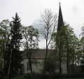 Lääne-Nigula church from the 13th/18th century in Nigula village.
 -
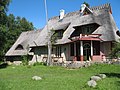 House museum of painter Ants Laikmaa in Kadarpiku village.
 -
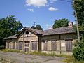 Former Risti railway station
 -
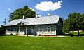 Risti library
 -
 Palivere Manor
 -
 Lääne-Nigula farmland


References
- ^ a b "Population by sex age group and administrative unit or type of settlement, 1 January". Statistics Estonia. Retrieved 22 October 2013.
External links
| Urban municipality | ||
|---|---|---|
| Rural municipalities | ||
58°57′14″N 23°45′08″E / 58.95389°N 23.75222°E
This Lääne County location article is a stub. You can help Wikipedia by expanding it. |