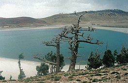
Lake Aguelmame Sidi Ali
Appearance
| Aguelmane Sidi Ali | |
|---|---|
 A view of the lake | |
| Location | Khenifra National Park, Morocco |
| Coordinates | 33°05′N 005°00′W / 33.083°N 5.000°W Google satellite map |
| Basin countries | Morocco |
| Surface area | 40 km2 (15 sq mi) |
| Max. depth | 36 m (118 ft) |
| Official name | Aguelmams Sidi Ali - Tifounassine |
| Designated | 15 January 2005 |
| Reference no. | 1468[1] |
Aguelmame Sidi Ali is a lake located in Khénifra Province, Béni Mellal-Khénifra, Morocco. Located at an altitude of 2,100 metres, Aguelmame Sidi Ali has a surface area of approximately 500 hectares and a depth of 36 metres. It borders the province of Ifrane within the Middle Atlas mountains.
References
- ^ "Aguelmams Sidi Ali - Tifounassine". Ramsar Sites Information Service. Retrieved 25 April 2018.
