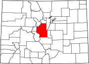
Lake George, Colorado
Lake George, Colorado | |
|---|---|
 | |
 | |
| Country | |
| State | |
| County | ParkTemplate:GR |
| Elevation | 7,992 ft (2,436 m) |
| Time zone | UTC-7 (MST) |
| • Summer (DST) | UTC-6 (MDT) |
| ZIP code[1] | 80827 |
| GNIS feature ID | 0191146 |
Lake George is an unincorporated town and a U.S. Post Office in Park County, Colorado, United States. The Lake George Post Office has the ZIP Code 80827.[1] It lies along U.S. Route 24 northwest of Colorado Springs, and several miles north of Florissant Fossil Beds National Monument.[2]
History
The town was a railroad stop and was named for the lake in New York. The lake itself freezes mostly solid in the wintertime, which made it ideal for railroad men to cut large blocks of ice from it in order to keep perishables cool. Also related to the town's railroading history, a short walk into the surrounding hills reveals Chinese bread ovens, from the period their labor was imported.
Geography
Lake George is located at 38°58′49″N 105°21′28″W / 38.98028°N 105.35778°WInvalid arguments have been passed to the {{#coordinates:}} function (38.980229,-105.357685).

Nearby is Camp Alexander, the Scout camp for Pikes Peak Council, as well as the Elevenmile Reservoir.
References
- ^ a b "ZIP Code Lookup" (JavaScript/HTML). United States Postal Service. December 28 2006. Retrieved December 28.
{{cite web}}: Check date values in:|accessdate=and|date=(help); Unknown parameter|accessyear=ignored (|access-date=suggested) (help) - ^ Rand McNally. The Road Atlas '06. Chicago: Rand McNally, 2006, p. 40.
External links

