
Lake Mohonk
| Lake Mohonk | |
|---|---|
 Lake Mohonk | |
| Location | Ulster County, New York |
| Coordinates | 41°45′58″N 074°09′25″W / 41.76611°N 74.15694°W |
| Basin countries | United States |
| Surface elevation | 1,253 ft (382 m) |
| Settlements | Marbletown |
Lake Mohonk is a lake in Ulster County, New York, United States.[1] It is located approximately 14 miles (23 km) northwest of Poughkeepsie. Activities on the lake are operated by Mohonk Mountain House.
Description
The small lake, one-half mile (800 m) long and 60 feet (18 m) deep, is located 1,245 feet (379 m) above sea level in the towns of Rochester and Marbletown near Sky Top Mountain, at 1,542 feet (470 m) one of the highest peaks of the Shawangunk Ridge.
The peak of Sky Top lies just east of the south end of the lake; to the west, Eagle Cliff rises to a height of 1,412 feet (430 m). Competitors in the Survival of the Shawangunks swim the lake as their final aquatic leg of the competition.[2]
-
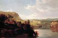 Lake Among the Hills (1858) by William Hart, on display at the White House
 -
 Lake Mohonk, 1881
 -
 Lake Mohonk, 1899
 -
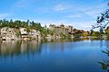 Lake Mohonk, 2011


_(14753574036).jpg)
.jpg)
References
- ^ "Mohonk Lake". Geographic Names Information System. United States Geological Survey, United States Department of the Interior.
- ^ Janon Fisher (September 13, 2004). "50 Miles of Scenic Suffering for Fun, Fitness and Health". New York Times. Retrieved October 6, 2012.
Sources
Wikimedia Commons has media related to Lake Mohonk.
- This article incorporates text from a publication now in the public domain: Chisholm, Hugh, ed. (1911). "Mohonk Lake". Encyclopædia Britannica. Vol. 18 (11th ed.). Cambridge University Press. p. 650.