Jump to content

Lao, Estonia

Coordinates: 58°14′55″N 24°06′17″E / 58.24861°N 24.10472°E / 58.24861; 24.10472
From Wikipedia, the free encyclopedia

This is an old revision of this page, as edited by InternetArchiveBot (talk | contribs) at 14:18, 11 May 2017 (Rescuing 1 sources and tagging 0 as dead. #IABot (v1.3.1)). The present address (URL) is a permanent link to this revision, which may differ significantly from the current revision.

Lao
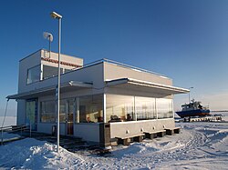
Munalaiu harbour in winter.
Lao is located in Estonia
Lao
Lao
Location in Estonia
Coordinates: 58°14′55″N 24°06′17″E / 58.24861°N 24.10472°E / 58.24861; 24.10472
CountryEstonia
CountyPärnu County
MunicipalityTõstamaa Parish
Population
 (01.01.2011[1])
 • Total31

Lao is a village in Tõstamaa Parish, Pärnu County, in southwestern Estonia. It is located on the top of the Tõstamaa peninsula, on the coast of the Gulf of Riga. Lao has a population of 31 as of 1 January 2011.[1]

Munalaiu harbour, which connects the islands Kihnu and Manilaid with the mainland, is located in Lao.

References

  1. ^ a b "Külad" (in Estonian). Tõstamaa vald. Archived from the original on 20 September 2011. Retrieved 23 May 2011. {{cite web}}: Unknown parameter |deadurl= ignored (|url-status= suggested) (help)

Template:Tõstamaa Parish