
Larrelt
Larrelt | |
|---|---|
 Aerial view of Larrelt | |
Location of Larrelt within Emden  | |
 Larrelt  Larrelt | |
| Coordinates: 53°21′55″N 7°09′24″E / 53.36525°N 7.15667°E | |
| Country | Germany |
| State | Lower Saxony |
| City | Emden |
| Elevation | 1 m (3 ft) |
| Population | |
| • Metro | 2,601 |
| Time zone | UTC+01:00 (CET) |
| • Summer (DST) | UTC+02:00 (CEST) |
| Dialling codes | 04921 |
| Vehicle registration | 26723 |
Larrelt is a former village in Lower Saxony, Germany. The centuries-old East Frisian village originally belonged to the former Landkreis Norden, but was added to the city of Emden as a district (Stadtteil) immediately after the Second World War. It currently lies directly to the north of the Emden industrial estate.
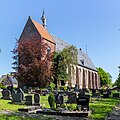
The oldest mention of Larrelt, as Hlarfliata, dates from the 10th century.[1] The former village has a church which dates from the 15th century.[2]
Gallery[edit]
-
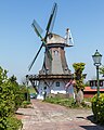 Windmill in Larrelt
 -
-
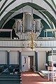 Organ in the church

.jpg)
.jpg)
References[edit]
- ^ Gysseling, Maurits (1975). "Enkele Belgische leenwoorden in de toponymie". Naamkunde (in Dutch). 7. Leuven/Amsterdam: Instituut voor Naamkunde/Commissie voor Naamkunde en Nederzettingsgeschiedenis: 5.
- ^ "Kirche". Ev.-reformierten Kirchengemeinde Larrelt (in German). Retrieved 17 October 2023.
External links[edit]
![]() Media related to Larrelt at Wikimedia Commons
Media related to Larrelt at Wikimedia Commons
This Emden location article is a stub. You can help Wikipedia by expanding it. |