
Lauterbach, Hesse
Lauterbach | |
|---|---|
 Lauterbach Chateau | |
 Coat of arms | |
Location of Lauterbach within Vogelsbergkreis district  | |
 Lauterbach  Lauterbach | |
| Coordinates: 50°38′16″N 9°23′40″E / 50.63778°N 9.39444°E | |
| Country | Germany |
| State | Hesse |
| Admin. region | Gießen |
| District | Vogelsbergkreis |
| Subdivisions | 10 Stadtteile |
| Government | |
| • Mayor | Rainer-Hans Vollmöller |
| Area | |
| • Total | 102 km2 (39 sq mi) |
| Highest elevation | 499 m (1,637 ft) |
| Lowest elevation | 272 m (892 ft) |
| Population (2022-12-31)[1] | |
| • Total | 13,880 |
| • Density | 140/km2 (350/sq mi) |
| Time zone | UTC+01:00 (CET) |
| • Summer (DST) | UTC+02:00 (CEST) |
| Postal codes | 36341 |
| Dialling codes | 06641, 06638 Wallenrod |
| Vehicle registration | VB |
| Website | www.lauterbach-hessen.de |
Lauterbach is a town in the Vogelsbergkreis district of the federal state of Hesse in central Germany. In 1983, the town hosted the 23rd Hessentag state festival.
History
Lauterbach was founded between 400 and 800 AD. In 812 the town was mentioned for the first time in a document of the church in Schlitz. In the Middle Ages, Lauterbach belonged to the cloister in Fulda. Then in the 12th century Lauterbach became a fief of the count Ziegenhein from the cloister in Fulda. In 1266, Lauterbach received municipal rights. In the same year, Lauterbach started to build the castle (Burg) and the city wall.
Over the following centuries, ownership rights of Lauterbach changed often and were complicated. Lauterbach became Lutheran following the Reformation. With a pact in 1684, Lauterbach came under the control of the Riedesel zu Eisenbach (Riedesel). Up to 1806, the Riedesels had a small but independent territory. Following the Napoleonic Wars and Congress of Vienna, Lauterbach belonged to the grand duchy of Hesse. In 1852, Lauterbach became the seat of the new founded district (Kreis) of Lauterbach. In 1972, local governments were re-organized, and the new, larger district Vogelsberg was founded of which Lauterbach remains the seat of government.
Villages that belong to Lauterbach
In 1972, several villages were incorporated into the town of Lauterbach: Allmenrod, Frischborn, Heblos, Maar, Reuters, Rimlos, Rudlos, Sickendorf, Wallenrod and Wernges.
Features
Ankerturm
The 'Ankerturm' is the only remaining tower of the city wall. It was used to be an observation tower. Temporarily it was also used as a prison.
Lauterbacher beer
Lauterbacher beer is the oldest beer in Hesse. The brand has existed since 1527.
Schrittsteine (Stepping stones)
The stepping stones were used as a shortcut to get to the local water fountain.
Hainigturm
The Hainigturm is a tower between Lauterbach and Angersbach. This tourist attraction was built in 1907.
Gallery
-
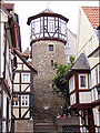 The 'Ankerturm', a tower in Lauterbach
 -
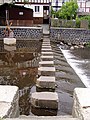 Stepping stones
 -
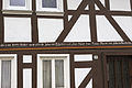 Cultural heritage monument in Lauterbach


_WLMMH_66026_2011-09-17_03.jpg)
People born in Lauterbach
- Friedrich Adolph Riedesel (born June 3, 1738, died January 6, 1800 in Braunschweig) -- general who commanded a Brunswick regiment on behalf of the British during the American Revolutionary War
- Fritz Selbmann (born September 29, 1899, died January 26, 1975 in Berlin) -- writer, minister and official member of the party in the GDR
People who lived in Lauterbach
- Peter Andreas Grünberg (born 18 May 1939 in Pilsen), won the nobel prize for physics in 2007. He spent his childhood and youth in Lauterbach. In 1959 he graduated from the Alexander-von-Humboldt-Gymnasium.
References
- ^ "Bevölkerung in Hessen am 31.12.2022 nach Gemeinden" (XLS) (in German). Hessisches Statistisches Landesamt. June 2023.
External links
Towns and municipalities in Vogelsberg (district) | ||
|---|---|---|
| International | |
|---|---|
| National | |
| Geographic | |