
Lengenfeld
Lengenfeld | |
|---|---|
 Coat of arms | |
Location of Lengenfeld within Vogtlandkreis district 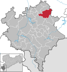 | |
 Lengenfeld  Lengenfeld | |
| Coordinates: 50°34′N 12°22′E / 50.567°N 12.367°E | |
| Country | Germany |
| State | Saxony |
| District | Vogtlandkreis |
| Subdivisions | 9 |
| Government | |
| • Mayor | Volker Bachmann |
| Area | |
| • Total | 46.98 km2 (18.14 sq mi) |
| Elevation | 403 m (1,322 ft) |
| Population (2022-12-31)[1] | |
| • Total | 7,013 |
| • Density | 150/km2 (390/sq mi) |
| Time zone | UTC+01:00 (CET) |
| • Summer (DST) | UTC+02:00 (CEST) |
| Postal codes | 08485 |
| Dialling codes | 037606 |
| Vehicle registration | V |
| Website | www.stadt-lengenfeld.de |
Lengenfeld is a town in the Vogtlandkreis district, in the Free State of Saxony, Germany. During World War II, a subcamp of Flossenbürg concentration camp was located here.[2] The town is situated 19 km southwest of Zwickau, and 18 km northeast of Plauen.
References
- ^ "Einwohnerzahlen nach Gemeinden als Excel-Arbeitsmappe" (XLS) (in German). Statistisches Landesamt des Freistaates Sachsen. 2024.
- ^ Christine O'Keefe. Concentration Camps
This Vogtlandkreis location article is a stub. You can help Wikipedia by expanding it. |