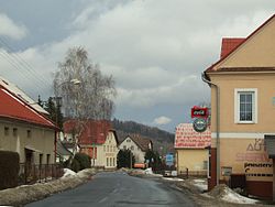
Lipová-lázně
Appearance
Lipová-lázně | |
|---|---|
Municipality | |
 Main street | |
| Country | |
| Region | Olomouc |
| District | Jeseník |
| Area | |
• Total | 44.37 km2 (17.13 sq mi) |
| Elevation | 498 m (1,634 ft) |
| Population (2012) | |
• Total | 2,397 |
| • Density | 54/km2 (140/sq mi) |
| Postal code | 790 61 až 790 63 |
| Website | http://www.lipova-lazne.cz |
Lipová-lázně (Template:Lang-de) is a municipality (obec) in Jeseník District in the Olomouc Region of the Czech Republic. It comprises two historical villages Horní Lipová (German Ober Lindewiese) and Dolní Lipová (German Nieder Lindewiese). The later also administers small settlement Bobrovník (German Bieberteich).[1]
The municipality covers an area of 44.37 square kilometres (17.13 sq mi), and has a population of 2,577 (as at 3 July 2006).
Lipová-lázně lies approximately 5 kilometres (3 mi) west of Jeseník, 71 km (44 mi) north of Olomouc, and 195 km (121 mi) east of Prague. It lies near the Hrubý Jeseník mountain range, and the municipality includes the peak of Šerák (1,351 m).
Administrative parts
- Village Dolní Lipová
- Village Horní Lipová
- Settlement Bobrovník
References
Wikimedia Commons has media related to Lipová-lázně.


