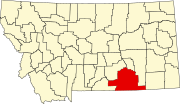
List of lakes of Big Horn County, Montana
Appearance
(Redirected from List of lakes in Big Horn County, Montana)
There are at least 18 named lakes and reservoirs in Big Horn County, Montana.
Lakes
[edit]- Arapooish Pond, 45°45′17″N 107°34′02″W / 45.75472°N 107.56722°W, el. 2,874 feet (876 m)[1]
- Crater Lake (Big Horn County, Montana), 45°17′46″N 108°24′40″W / 45.29611°N 108.41111°W, el. 7,313 feet (2,229 m)[2]
- Little Hawk Lake, 45°35′51″N 106°55′25″W / 45.59750°N 106.92361°W, el. 3,428 feet (1,045 m)[3]
- Muddy Lake, 45°25′07″N 106°49′58″W / 45.41861°N 106.83278°W, el. 4,459 feet (1,359 m)[4]
Reservoirs
[edit]- Bighorn Reservoirs, 45°18′24″N 107°57′29″W / 45.30667°N 107.95806°W, el. 3,642 feet (1,110 m)[5]
- Brown Reservoir, 45°10′03″N 107°18′47″W / 45.16750°N 107.31306°W, el. 3,747 feet (1,142 m)[6]
- Chalk Butte Reservoir, 45°11′40″N 107°18′38″W / 45.19444°N 107.31056°W, el. 3,655 feet (1,114 m)[7]
- Halfway Reservoir, 45°09′43″N 107°21′04″W / 45.16194°N 107.35111°W, el. 3,743 feet (1,141 m)[8]
- Liming Reservoir, 45°12′50″N 107°18′33″W / 45.21389°N 107.30917°W, el. 3,586 feet (1,093 m)[9]
- Lodge Grass Reservoir, 45°10′00″N 107°36′02″W / 45.16667°N 107.60056°W, el. 4,144 feet (1,263 m)[10]
- Lodge Grass Storage Reservoir, 45°09′50″N 107°35′49″W / 45.16389°N 107.59694°W, el. 4,144 feet (1,263 m)[11]
- Lower Indian Creek Reservoir, 45°16′21″N 107°00′48″W / 45.27250°N 107.01333°W, el. 4,108 feet (1,252 m)[12]
- Rednose Reservoir, 45°32′10″N 106°59′28″W / 45.53611°N 106.99111°W, el. 3,448 feet (1,051 m)[13]
- Steinhilber Reservoir, 45°12′39″N 107°15′06″W / 45.21083°N 107.25167°W, el. 3,701 feet (1,128 m)[14]
- Tongue River Reservoir, 45°07′50″N 106°45′58″W / 45.13056°N 106.76611°W, el. 3,442 feet (1,049 m)[15]
- Two Moon Reservoir, 45°33′59″N 106°52′11″W / 45.56639°N 106.86972°W, el. 3,415 feet (1,041 m)[16]
- Upper Indian Creek Reservoir, 45°16′13″N 107°01′18″W / 45.27028°N 107.02167°W, el. 4,121 feet (1,256 m)[17]
- Yellowtail Afterbay Reservoir, 45°19′06″N 107°55′26″W / 45.31833°N 107.92389°W, el. 3,209 feet (978 m)[18]
See also
[edit]Notes
[edit]- ^ "Arapooish Pond". Geographic Names Information System. United States Geological Survey, United States Department of the Interior.
- ^ "Crater Lake". Geographic Names Information System. United States Geological Survey, United States Department of the Interior.
- ^ "Little Hawk Lake". Geographic Names Information System. United States Geological Survey, United States Department of the Interior.
- ^ "Muddy Lake". Geographic Names Information System. United States Geological Survey, United States Department of the Interior.
- ^ "Bighorn Lake". Geographic Names Information System. United States Geological Survey, United States Department of the Interior.
- ^ "Brown Reservoir". Geographic Names Information System. United States Geological Survey, United States Department of the Interior.
- ^ "Chalk Butte Reservoir". Geographic Names Information System. United States Geological Survey, United States Department of the Interior.
- ^ "Halfway Reservoir". Geographic Names Information System. United States Geological Survey, United States Department of the Interior.
- ^ "Liming Reservoir". Geographic Names Information System. United States Geological Survey, United States Department of the Interior.
- ^ "Lodge Grass Reservoir". Geographic Names Information System. United States Geological Survey, United States Department of the Interior.
- ^ "Lodge Grass Storage Reservoir". Geographic Names Information System. United States Geological Survey, United States Department of the Interior.
- ^ "Lower Indian Creek Reservoir". Geographic Names Information System. United States Geological Survey, United States Department of the Interior.
- ^ "Rednose Reservoir". Geographic Names Information System. United States Geological Survey, United States Department of the Interior.
- ^ "Steinhilber Reservoir". Geographic Names Information System. United States Geological Survey, United States Department of the Interior.
- ^ "Tongue River Reservoir". Geographic Names Information System. United States Geological Survey, United States Department of the Interior.
- ^ "Two Moon Reservoir". Geographic Names Information System. United States Geological Survey, United States Department of the Interior.
- ^ "Upper Indian Creek Reservoir". Geographic Names Information System. United States Geological Survey, United States Department of the Interior.
- ^ "Yellowtail Afterbay Reservoir". Geographic Names Information System. United States Geological Survey, United States Department of the Interior.

